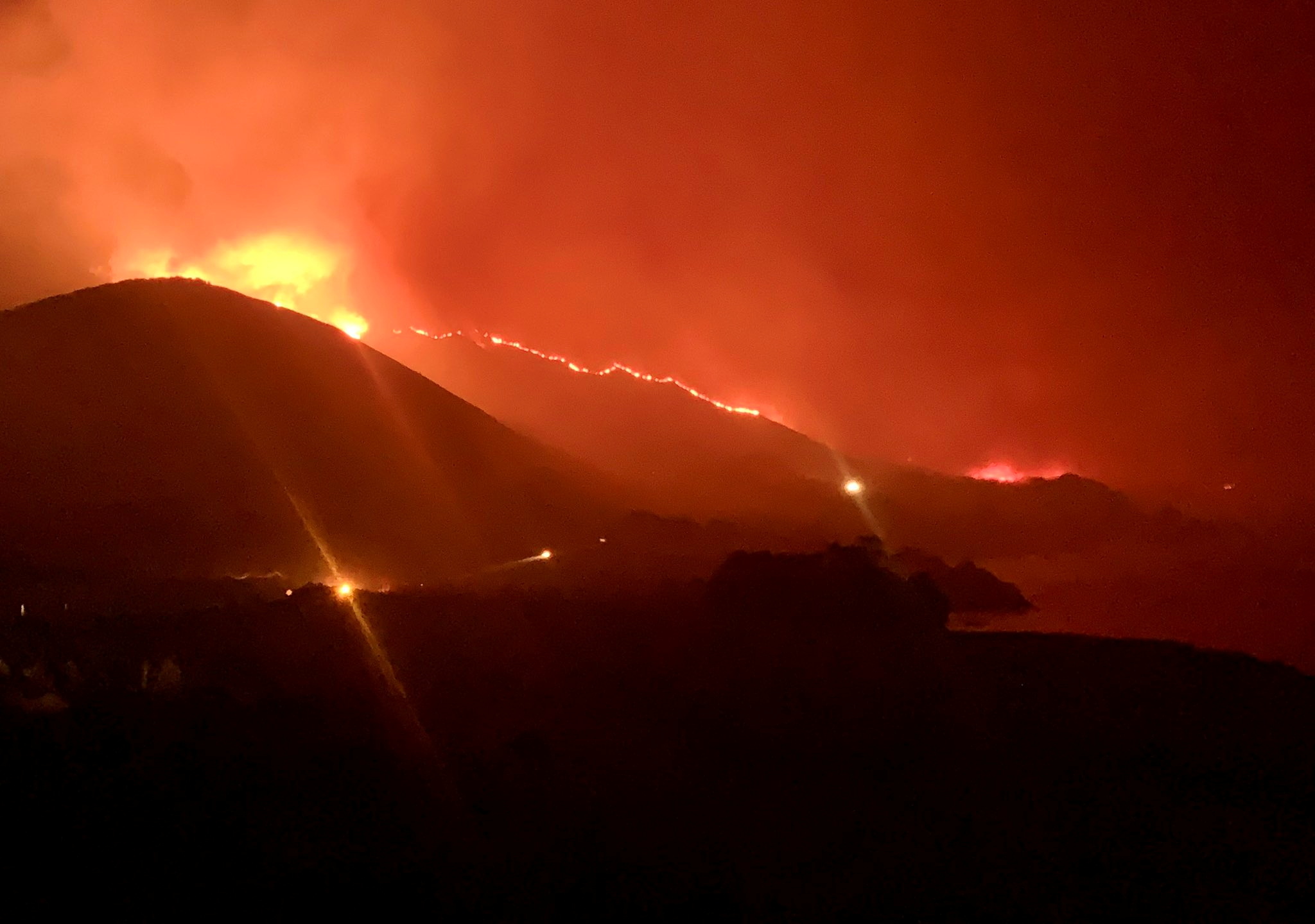
Wildfire burns in Rocky Point, Monterey County, California, U.S., in this handout photo taken over the night of January 21st or 22nd, 2022. DEBI LORENC/Handout via REUTERS
Register now for FREE unlimited access to Reuters.com
Register
Jan 22 (Reuters) – A 1,500-acre fire near the coastal community of Big Sur, California triggered evacuations and closed part of a major highway, state and local officials said on Saturday.
The Colorado Fire, which has been active since Friday, was 5% contained, the California Department of Forestry and Fire Protection (Cal Fire) said.
A 20-mile stretch of State Highway 1, a scenic north-south route on the Pacific Coast, was closed from near the beach town of Carmel-by-the-Sea to Andrew Molera State Park.
About 400 people in Monterey County were evacuated from 1,100 structures, a spokeswoman for the American Red Cross said, citing county reports.
Four people and a pet stayed overnight at a shelter in a local school, the Red Cross said.
California has long had an active wildfire season, but in recent years, fueled at least in part by climate change, it has grown longer and more punishing.
Last year, the wildfire season started unusually early amid an ongoing drought and low reservoir levels, Cal Fire said. In January 2021 alone, the state battled 297 fires on 1,171 acres, the office said.
The Colorado Fire is the only fire listed on Cal Fire’s incident list so far in 2022.
This year, California is also grappling with the Santa Ana winds. A high wind warning was in effect for the area, with possible gusts of up to 70 miles per hour (112.65 kph), according to the National Weather Service.
But winds had improved and were forecast to remain light throughout the weekend, the Red Cross said.
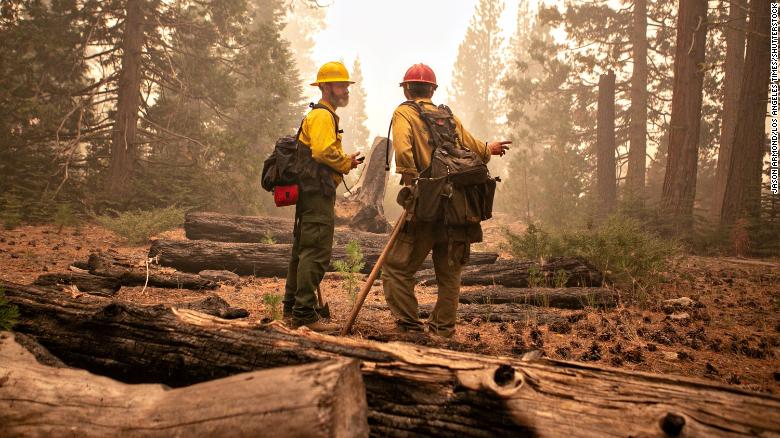
Flames burn up a tree as part of the Windy Fire in the Trail of 100 Giants grove last month in Sequoia National Forest, Calif.Noah Berger/AP
LOS ANGELES — Northern California wildfires may have killed hundreds of giant sequoias as they swept through groves of the majestic monarchs in the Sierra Nevada, an official said Wednesday.
“It’s heartbreaking,” said Christy Brigham, head of resource management and science for Sequoia and Kings Canyon national parks.
The lightning-caused KNP Complex that erupted on Sept. 9 has burned into 15 giant sequoia groves in the park, Brigham said.
More than 2,000 firefighters were battling the blaze in sometimes treacherous terrain. On Wednesday afternoon, four people working on the fire were injured when a tree fell on them, the National Park Service reported.
The four were airlifted to hospitals and “while the injuries are serious, they are in stable condition,” the report said. It didn’t provide other details.
The KNP Complex was only 11% contained after burning 134 square miles (347 square kilometers) of forest. Cooler weather has helped slow the flames and the area could see some slight rain on Friday, forecasters said.
The fire’s impact on giant sequoia groves was mixed. Most saw low- to medium-intensity fire behavior that the sequoias have evolved to survive, Brigham said.Article continues after sponsor messagehttps://aceda22c35b90ff6f953bfabead7e4f4.safeframe.googlesyndication.com/safeframe/1-0-38/html/container.html
However, it appeared that two groves — including one with 5,000 trees — were seared by high-intensity fire that can send up 100-foot (30-meter) flames capable of burning the canopies of the towering trees.
That leaves the monarchs at risk of going up “like a horrible Roman candle,” Brigham said.
Two burned trees fell in Giant Forest, which is home to about 2,000 sequoias, including the General Sherman Tree, which is considered the world’s largest by volume. However, the most notable trees survived and Brigham said the grove appeared to be mostly intact.
Firefighters have taken extraordinary measures to protect the sequoias by wrapping fire-resistant material around the bases of some giants, raking and clearing vegetation around them, installing sprinklers and dousing some with water or fire retardant gel.
However, the full extent of the damage won’t be known for months, Brigham said. Firefighters are still occupied protecting trees, homes and lives or can’t safely reach steep, remote groves that lack roads or even trails, she said.
To the south, the Windy Fire had burned at least 74 sequoias, Garrett Dickman told the Los Angeles Times. The wildfire botanist has recorded damage as part of a sequoia task force preparing and assessing trees in the fire zone.
In one grove, Dickman counted 29 sequoias that were “just incinerated,” he told CNN.
“There were four of those that had burned so hot that they’d fallen over,” he said.
The 152-acre (395-square-kilometer) fire was 75% contained.
Giant sequoias grow naturally only in the Sierra Nevada. The world’s most massive trees, they can soar to more than 250 feet (76 meters) with trunks 20 feet (6 meters) in diameter and live for thousands of years.
The trees need low-intensity fire to reproduce. Flames thin out the forest of competitors such as cedars, clearing away shade, and the heat causes the seedlings to open. But fire officials say recent blazes have been much more intense because fire suppression efforts left more undergrowth that’s turned bone dry from drought, driven by climate change.
Last year’s Castle Fire in and around Sequoia National Park is estimated to have killed as many as 10,600 giant sequoias, or 10% to 14% of the entire population.
While some groves may have received only patchy fire damage and will recover, every burned giant sequoia is a loss, Brigham said.
“When you stand by a tree that big and that old, 1,000 to 2,000 years old, the loss of any is a heartbreak,” she said. “You can’t get it back, it’s irreplaceable.”
California fires have burned more than 3,000 square miles (7,800 square kilometers) so far in 2021, destroying more than 3,000 homes, commercial properties and other structures. Hotter and drier weather coupled with decades of fire suppression have contributed to an increase in the number of acres burned by wildfires, fire scientists say. And the problem is exacerbated by a more than 20-year Western megadrought that studies link to human-caused climate change.
Paul DuginskiSat, September 25, 2021, 5:00 AM·4 min read
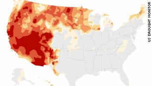
Almost half of California is in what the U.S. Drought Monitor calls “exceptional drought.” (Paul Duginski / Los Angeles Times)
Increasing evaporative demand is escalating summertime drought severity in California and the West, according to climate researchers.
Evaporative demand is essentially the atmosphere’s “thirst.” It is calculated based on temperature, humidity, wind speed and solar radiation. It’s the sum of evaporation and transpiration from plants, and it’s driven by warmer global temperatures, which can be attributed to climate change.
The meteorological summer of 2021 in the contiguous United States, which runs from June through August, tied the extreme heat of the Dust Bowl summer in 1936.- ADVERTISEMENT -https://s.yimg.com/rq/darla/4-6-0/html/r-sf-flx.html
California and the West have seen a substantial increase in evaporative demand over the last half-century, worsening summer drought severity, said John Abatzoglou, an associate professor and climate scientist at UC Merced.
The drought in California isn’t just the result of a scarcity of precipitation. It is a combination of two things: a lack of rain and those thirsty atmospheric conditions that desiccate the landscape. For much of California, the 2021 summer and water year have had the highest evaporative demand in the last 40 years, according to the National Integrated Drought Information System.
As Abatzoglou points out, Northern California has endured the third-driest water year on record along with the highest recorded evaporative demand — factors that “place this year in a class by itself.” These things are remarkable, he adds, “given that the California drought hall of infamy is notorious.”
Abatzoglou cites the Palmer Drought Severity Index, which he describes as a general catch-all drought index widely used in the U.S., and part of what informs the U.S. Drought Monitor. According to that yardstick, Northern California is having its worst year in the instrumental record. The PDSI is a soil moisture index that accounts for both precipitation and evaporative demand.
Abatzoglou sees the “demand” side of the drought as something we’re beginning to appreciate. He says there have been dry droughts and then there have been hot and dry droughts. The latter have promoted increased summertime irrigation demands by agriculture in the Central Valley, energy imbalances due to higher demand caused by heat and reduced energy supply due to the reduction in hydroelectric power generation.
By some drought measures, Northern California is having its worst year on record. (Paul Duginski / Los Angeles Times)
The latest U.S. Drought Monitor report, released Thursday, paints a dire picture of the situation in California and much of the West — as it has for months. In the current data, about 46% of the state is categorized as being in exceptional drought, while just over 42% is in extreme drought. The remaining approximately 12% of the state is about evenly divided between moderate and severe drought — meaning that 100% of the state is stricken by some level of drought.
Increased evaporative demand has exacerbated the dryness in vegetation that has enabled more wildfires this year. Active wildfires such as the Windy fire and the KNP Complex fires were among those that continued to consume parched vegetation in California.
Evaporative demand was the highest on record in parts of Northern and Central California. (Paul Duginski / Los Angeles Times)
The areas of exceptional and extreme drought in the Drought Monitor map track fairly closely with the pattern where evaporative demand in the state — that measure of a thirsty atmosphere — ranks as the highest on record for June through August. This oxblood-colored part of the map indicates the biggest departures from normal from California summers from 1980 to 2021.
In November, Science Daily quoted Abatzoglou as saying: “Increased evaporative demand with warming enables fuels to be drier for longer periods. This is a recipe for more active fire seasons.”
That prediction has been borne out in the summer of 2021.
Furthermore, in an April 2020 paper in the journal Science, on which Abatzoglou was one of the authors, the massive, continuing drought afflicting the U.S. Southwest was estimated to be 46% more acute because of human-caused climate change.
Another study a few years ago, by Abatzoglou and others, estimated that the 2012-2014 drought in California was 8% to 27% more severe because of a warming climate.
There have always been cyclical droughts in California and the West, but scientific evidence indicates that human-caused climate change is creating a warmer, thirstier atmosphere that sucks the moisture out of the landscape.
“The increase in evaporative demand is akin to putting an additional straw in one’s drink,” Abatzoglou said. “It is now that much easier to drain the cup.”
In mid-September, the National Park Service finalized a General Management Plan Amendment (GMPA) for the Point Reyes National Seashore, changing a rule to allow livestock production to continue for 20 years in this national park in the San Francisco Bay area of California. This rule change, and the ranching it enables, poses an immediate threat to the local environment, the global climate and the people of San Francisco, especially its underserved communities. It also sets an alarming precedent for degrading national parks throughout the country.
Northern California is facing some of the most dangerous climate impacts in the United States. This region leads the nation in terms of drought, wildfires, smoke and ocean degradation. Our summers are gone, and each year is worse than the last. Livestock production in Point Reyes directly fuels these climate impacts by emitting thousands of tons of methane gas from cattle, which goes on to trap heat in the atmosphere. According to the recent IPCC report, one of the most important steps we can take as a global community to mitigate global warming is by addressing methane — and that can start by phasing out ranching in what should be a pristine wilderness area.
Livestock production creates other forms of pollution as well, degrading the health of the ocean and coast. Ranchers in Point Reyes liquefy their cows’ manure and spread it over the landscape to grow the plants that later get eaten by the cattle. After rainfall, this effluent washes into the ocean and into the Greater Farallones National Marine Sanctuary, threatening the marine mammals and endangered species living underwater in Point Reyes and the nearby marine sanctuary. This has negative impacts on native species like coho salmon. There is no other national park in the entire system that is degrading the land and water as significantly as Point Reyes is, contrary to the laws that require it to be protected.https://1f11226b224e7d5411234c4abccc8311.safeframe.googlesyndication.com/safeframe/1-0-38/html/container.html
On top of the pollution, livestock production in Point Reyes impedes public access to the park — directly contradicting its established purpose. Ranching takes up one-third of the park’s acreage, and almost 400 miles of fencing keep visitors out.
Lack of public access is a critical issue for many reasons. From a purely economic perspective, tourism generates billions of dollars every year, and the economic benefits of national parks number in the trillions for the mental health gains alone. But the harmful environmental impact of ranching has the opposite effect on tourism and mental health. At a time when COVID-19 is threatening public health, time spent in parks can help improve physical health, by addressing the comorbidities that make the disease more severe, and by improving mental health, by exposing people to more biodiversity.
The burden of pollution, lack of public access, and loss of these mental and physical health benefits do not fall equally on everyone — it is actively detrimental to equity and racial justice. For one, fencing, cows, ruts and guard dogs make the area hostile to visitors and especially unwelcoming to communities of color. Also, it reduces access for disabled visitors with mobility or vision impairments — imagine your main experience of Point Reyes is the smell of cattle operations. Lastly, thousands of children from underserved communities are brought to the park each year on scholarships. Many of them have never seen a beach and are rarely able to play in some of the dangerous neighborhoods where they live. But instead of a first-class national park experience, we are bringing these children to a cesspool of commercial ranching.
This is at a time when communities of color are suffering the most from COVID-19 and climate impacts and need accessible green space all the more. The idea that we have taken a national park and degraded it to make it a worse place for communities is shocking. Where is environmental justice in this reality?
Instead of approving a new rule that would entrench and expand livestock production in a national park, the National Park Service should phase out the ranches, as was originally planned when the park was founded. The land must be restored, the invasive species removed and the cattle lots turned into vibrant coastal ecosystems.
We can make this park a much healthier area for the public, especially for those who don’t have access to other parks in the national park system. By removing sources of methane and fecal pollution and restoring the original landscape and vision for the park, we can make Point Reyes a key component of California’s climate action and vision for 30×30 — and a model for restoring environmental justice.
CNN)Firefighters in California made significant progress against the Caldor Fire over the weekend, allowing for some evacuation orders in the Lake Tahoe region to be downgraded. But as residents there began to breathe a sigh of relief, three new fires ignited in the state Sunday, according to Cal Fire.Evacuation orders for the city of South Lake Tahoe were downgraded to evacuation warnings, nearly a week after thousands in the resort town clogged roadways when officials told them get out because flames were racing into the area.
The areas of Fallen Leaf Lake, Christmas Valley, Meyers and North Upper Truckee remain under an evacuation order.
Across the state border in Nevada, mandatory evacuations in Douglas County were downgraded to precautionary evacuations Saturday, according to an announcement on the county’s website, opening the door for some residents there to return home.
As of Monday morning, the Caldor Fire had consumed 216,358 acres near the California-Nevada border. The flames are 44% contained about three weeks after it started on August 14, Cal Fire said.Enter your email to sign up for CNN’s “Meanwhile in China” Newsletter.close dialog
Get the latest storm and extreme weather updates delivered straight to your inbox from CNN.Sign Me UpBy subscribing you agree to ourprivacy policy.While still massive, the Caldor Fire’s growth slowed over the weekend, adding just 842 acres in a 24-hour period between Friday night and Saturday night, according to CNN’s analysis of fire information. That’s a far cry from its explosive start, when the fire grew to nearly 100,000 acres in its first week.
High temperatures ahead
Saturday night, fire behavior in the Caldor Fire’s East Zone was “minimal to moderate,” Cal Fire said in an update Sunday evening.”There is still much work to be done tying in dozer lines and holding along the south and southeast flank of the fire above Caples Lake. However so far, firefighters are making good progress,” the report said.As firefighters measure their progress, they are also keeping an eye on the forecast as another heat wave is shaping up for this week.
Is this *finally* the moment we wake up to the climate crisis?Nearly 25 million in California, Nevada, and Arizona will experience temperatures up to 20 degrees above average, meaning the region could see 105 to 115 degrees, CNN meteorologist Michael Guy said. The majority of the heat will impact the desert Southwest.At the same time, a red flag warning is in effect for portions of central Oregon and central northern California on Tuesday, meaning conditions will be optimal for fire to spread, Guy said.In the meantime, fire officials urged those returning to their homes to do so safely and keep an eye on updates.”Repopulation consists of complex coordination between, fire, law enforcement, public works, and utilities to ensure the safety of residents and fire responders alike,” Cal Fire said.The Caldor Fire has destroyed more than 900 structures since it began, including homes, business and other buildings, Cal Fire said. More than 27,000 structures are threatened.
Photos: Wildfires raging in the WestCalifornia Gov. Gavin Newsom, left, and Nevada Gov. Steve Sisolak tour an area destroyed by the Tamarack Fire in Gardnerville, Nevada, on July 28.Hide Caption35 of 68
Photos: Wildfires raging in the WestFirefighter Brentt Call walks through a burned-over area of the Bootleg Fire near Klamath Falls, Oregon, on July 27.Hide Caption36 of 68
Photos: Wildfires raging in the WestCal Fire Capts. Tristan Gale, left, and Derek Leong monitor a firing operation in California’s Lassen National Forest on July 26. Crews had set a ground fire to stop the Dixie Fire from spreading.Hide Caption37 of 68
Photos: Wildfires raging in the WestFirefighters try to reach a fire site in Quincy, California, on July 25.Hide Caption38 of 68
Photos: Wildfires raging in the WestVolunteers sort clothing at a donation shelter for those affected by the Bootleg Fire in Bly, Oregon.Hide Caption39 of 68
Photos: Wildfires raging in the WestScott Griffin surveys his property, which was destroyed by the Bootleg Fire in Sycan Estates, Oregon.Hide Caption40 of 68
Photos: Wildfires raging in the WestFlames consume a home as the Dixie Fire tears through the Indian Falls community of Plumas County, California, on July 24.Hide Caption41 of 68
Photos: Wildfires raging in the WestPeople stand behind the fire line as flames from the Steptoe Canyon Fire spread through dry grass in Colton, Washington, on July 22.Hide Caption42 of 68
Photos: Wildfires raging in the WestPlumes of smoke from the Dixie Fire rise above California’s Plumas National Forest, near the Pacific Gas and Electric Rock Creek Power House, on July 21.Hide Caption43 of 68
Photos: Wildfires raging in the WestFirefighters walk near a wildfire in Topanga, California, on July 19.Hide Caption44 of 68
Photos: Wildfires raging in the WestA firefighter does mop-up work in the Fremont-Winema National Forest, which has been struggling with the Bootleg Fire in Oregon.Hide Caption45 of 68
Photos: Wildfires raging in the WestA car is charred by the Bootleg Fire along a mountain road near Bly, Oregon.Hide Caption46 of 68
Photos: Wildfires raging in the WestNicolas Bey, 11, hugs his father, Sayyid, near a donated trailer they are using after their home was burned in the Bootleg Fire near Beatty, Oregon.Hide Caption47 of 68
Photos: Wildfires raging in the WestFirefighters extinguish hot spots in an area affected by the Bootleg Fire near Bly, Oregon.Hide Caption48 of 68
Photos: Wildfires raging in the WestA bear cub clings to a tree after being spotted by a safety officer at the Bootleg Fire in Oregon.Hide Caption49 of 68
Photos: Wildfires raging in the WestFirefighters work to protect Markleeville, California, from the Tamarack Fire on July 17. The Tamarack Fire was started by a lightning strike.Hide Caption50 of 68
Photos: Wildfires raging in the WestThe Tamarack Fire burns in Markleeville, near the California-Nevada border, on July 17.Hide Caption51 of 68
Photos: Wildfires raging in the WestA member of the Northwest Incident Management Team 12 holds a map of the Chuweah Creek Fire as wildfires devastated Nespelem, Washington, on July 16.Hide Caption52 of 68
Photos: Wildfires raging in the WestA cloud from the Bootleg Fire drifts into the air near Bly, Oregon, on July 16.Hide Caption53 of 68
Photos: Wildfires raging in the WestFirefighters spray water from the Union Pacific Railroad’s fire train while battling the Dixie Fire in California’s Plumas National Forest on July 16.Hide Caption54 of 68
Photos: Wildfires raging in the WestHorses climb a hillside that was burned by the Chuweah Creek Fire in eastern Washington.Hide Caption55 of 68
Photos: Wildfires raging in the WestFire from the Bootleg Fire illuminates smoke near Bly, Oregon, on the night of July 16.Hide Caption56 of 68
Photos: Wildfires raging in the WestA firefighter battles the Bootleg Fire in the Fremont-Winema National Forest, along the Oregon and California border, on July 15.Hide Caption57 of 68
Photos: Wildfires raging in the WestA firefighting aircraft drops flame retardant on the Bootleg Fire in Bly, Oregon, on July 15.Hide Caption58 of 68
Photos: Wildfires raging in the WestFirefighters dig away at hot spots underneath stumps and brush after flames from the Snake River Complex Fire swept through the area south of Lewiston, Idaho, on July 15.Hide Caption59 of 68
Photos: Wildfires raging in the WestBurned cars sit outside a home that was destroyed by the Chuweah Creek Fire in Nespelem, Washington.Hide Caption60 of 68
Photos: Wildfires raging in the WestEvacuee Dee McCarley hugs her cat Bunny at a Red Cross center in Klamath Falls, Oregon, on July 14.Hide Caption61 of 68
Photos: Wildfires raging in the WestAn airplane drops fire retardant on the Chuweah Creek Fire in Washington on July 14.Hide Caption62 of 68
Photos: Wildfires raging in the WestOperations Section Chief Bert Thayer examines a map of the Bootleg Fire in Chiloquin, Oregon, on July 13.Hide Caption63 of 68
Photos: Wildfires raging in the WestFire consumes a home as the Sugar Fire, part of the Beckwourth Complex Fire, tears through Doyle, California, on July 10. It’s the second time in less than a year that the small town has been ravaged by a wildfire.Hide Caption64 of 68
Photos: Wildfires raging in the WestMen hug a member of the Red Cross at a Bootleg Fire evacuation center in Klamath Falls, Oregon.Hide Caption65 of 68
Photos: Wildfires raging in the WestEmbers blow across a field as the Sugar Fire burns in Doyle, California, on July 9.Hide Caption66 of 68
Photos: Wildfires raging in the WestFirefighters monitor the Sugar Fire in Doyle, California, on July 9.Hide Caption67 of 68
Photos: Wildfires raging in the WestIn this long-exposure photograph, taken early on July 2, flames surround a drought-stricken Shasta Lake during the Salt Fire in Lakehead, California.Hide Caption68 of 68
Photos: Wildfires raging in the WestA helicopter flies over Wrights Lake while battling the Caldor Fire in California’s Eldorado National Forest on Wednesday, September 1.
See picturesque Lake Tahoe obscured by smoke from wildfire 02:21
(CNN)The raging Caldor Fire in Northern California prompted evacuation orders and warnings in the Lake Tahoe Basin Sunday night after fire conditions resulted in rapid spread, causing at least one hospital to transfer all of its patients out amid the flames.All patients were being evacuated from Barton Memorial Hospital in South Lake Tahoe.”Patients will be transferred to regional partner facilities & patients’ families will be notified,” the hospital said in a tweet Sunday night. “Barton’s Emergency Department remains open for emergent health needs only.”
Five people have been injured in the fire that has destroyed more than 650 structures and damaged nearly 40 more since it began August 14, Cal Fire said.
Photos: Wildfires raging in the WestFirefighters try to reach a fire site in Quincy, California, on July 25.Hide Caption31 of 61
Photos: Wildfires raging in the WestVolunteers sort clothing at a donation shelter for those affected by the Bootleg Fire in Bly, Oregon.Hide Caption32 of 61
Photos: Wildfires raging in the WestScott Griffin surveys his property, which was destroyed by the Bootleg Fire in Sycan Estates, Oregon.Hide Caption33 of 61
Photos: Wildfires raging in the WestFlames consume a home as the Dixie Fire tears through the Indian Falls community of Plumas County, California, on July 24.Hide Caption34 of 61
Photos: Wildfires raging in the WestPeople stand behind the fire line as flames from the Steptoe Canyon Fire spread through dry grass in Colton, Washington, on July 22.Hide Caption35 of 61
Photos: Wildfires raging in the WestPlumes of smoke from the Dixie Fire rise above California’s Plumas National Forest, near the Pacific Gas and Electric Rock Creek Power House, on July 21.Hide Caption36 of 61
Photos: Wildfires raging in the WestFirefighters walk near a wildfire in Topanga, California, on July 19.Hide Caption37 of 61
Photos: Wildfires raging in the WestA firefighter does mop-up work in the Fremont-Winema National Forest, which has been struggling with the Bootleg Fire in Oregon.Hide Caption38 of 61
Photos: Wildfires raging in the WestA car is charred by the Bootleg Fire along a mountain road near Bly, Oregon.Hide Caption39 of 61
Photos: Wildfires raging in the WestNicolas Bey, 11, hugs his father, Sayyid, near a donated trailer they are using after their home was burned in the Bootleg Fire near Beatty, Oregon.Hide Caption40 of 61
Photos: Wildfires raging in the WestFirefighters extinguish hot spots in an area affected by the Bootleg Fire near Bly, Oregon.Hide Caption41 of 61
Photos: Wildfires raging in the WestA bear cub clings to a tree after being spotted by a safety officer at the Bootleg Fire in Oregon.Hide Caption42 of 61
Photos: Wildfires raging in the WestFirefighters work to protect Markleeville, California, from the Tamarack Fire on July 17. The Tamarack Fire was started by a lightning strike.Hide Caption43 of 61
Photos: Wildfires raging in the WestThe Tamarack Fire burns in Markleeville, near the California-Nevada border, on July 17.Hide Caption44 of 61
Photos: Wildfires raging in the WestA member of the Northwest Incident Management Team 12 holds a map of the Chuweah Creek Fire as wildfires devastated Nespelem, Washington, on July 16.Hide Caption45 of 61
Photos: Wildfires raging in the WestA cloud from the Bootleg Fire drifts into the air near Bly, Oregon, on July 16.Hide Caption46 of 61
Photos: Wildfires raging in the WestFirefighters spray water from the Union Pacific Railroad’s fire train while battling the Dixie Fire in California’s Plumas National Forest on July 16.Hide Caption47 of 61
Photos: Wildfires raging in the WestHorses climb a hillside that was burned by the Chuweah Creek Fire in eastern Washington.Hide Caption48 of 61
Photos: Wildfires raging in the WestFire from the Bootleg Fire illuminates smoke near Bly, Oregon, on the night of July 16.Hide Caption49 of 61
Photos: Wildfires raging in the WestA firefighter battles the Bootleg Fire in the Fremont-Winema National Forest, along the Oregon and California border, on July 15.Hide Caption50 of 61
Photos: Wildfires raging in the WestA firefighting aircraft drops flame retardant on the Bootleg Fire in Bly, Oregon, on July 15.Hide Caption51 of 61
Photos: Wildfires raging in the WestFirefighters dig away at hot spots underneath stumps and brush after flames from the Snake River Complex Fire swept through the area south of Lewiston, Idaho, on July 15.Hide Caption52 of 61
Photos: Wildfires raging in the WestBurned cars sit outside a home that was destroyed by the Chuweah Creek Fire in Nespelem, Washington.Hide Caption53 of 61
Photos: Wildfires raging in the WestEvacuee Dee McCarley hugs her cat Bunny at a Red Cross center in Klamath Falls, Oregon, on July 14.Hide Caption54 of 61
Photos: Wildfires raging in the WestAn airplane drops fire retardant on the Chuweah Creek Fire in Washington on July 14.Hide Caption55 of 61
Photos: Wildfires raging in the WestOperations Section Chief Bert Thayer examines a map of the Bootleg Fire in Chiloquin, Oregon, on July 13.Hide Caption56 of 61
Photos: Wildfires raging in the WestFire consumes a home as the Sugar Fire, part of the Beckwourth Complex Fire, tears through Doyle, California, on July 10. It’s the second time in less than a year that the small town has been ravaged by a wildfire.Hide Caption57 of 61
Photos: Wildfires raging in the WestMen hug a member of the Red Cross at a Bootleg Fire evacuation center in Klamath Falls, Oregon.Hide Caption58 of 61
Photos: Wildfires raging in the WestEmbers blow across a field as the Sugar Fire burns in Doyle, California, on July 9.Hide Caption59 of 61
Photos: Wildfires raging in the WestFirefighters monitor the Sugar Fire in Doyle, California, on July 9.Hide Caption60 of 61
Photos: Wildfires raging in the WestIn this long-exposure photograph, taken early on July 2, flames surround a drought-stricken Shasta Lake during the Salt Fire in Lakehead, California.Hide Caption61 of 61
Photos: Wildfires raging in the WestFirefighters with the Eldorado National Forest address the Caldor Fire in Strawberry, California, on Friday, August 27. The raging fire has prompted evacuation orders and warnings in the Lake Tahoe Basin.
The warning, which signifies that there is “a potential threat to life and/or property” was expanded for additional parts of the basin, Cal Fire said in an alert Sunday.Enter your email to sign up for CNN’s “Meanwhile in China” Newsletter.close dialog
Get the latest storm and extreme weather updates delivered straight to your inbox from CNN.Sign Me UpBy subscribing you agree to ourprivacy policy.“Those who require additional time to evacuate and those with pets and livestock should leave now,” the alert warned.
The West’s historic drought in 3 mapsInciweb’s incident report on the Caldor Fire said the increase in spread was due largely to wind gusts between 25-35 mph and relative humidity between 10-15%.Critical fire weather conditions are expected in the coming days, according to a tweet from the National Weather Service in Sacramento, with gusts of 20 to 35 mph possible in the afternoons and evenings.The agency said in a tweet Sunday that smoke from the wildfires has created poor air quality across the region, with some locations in the hazardous category.A red flag warning will be in place from Monday night until Tuesday as humidity values will run as low as 5-10%, according to CNN Meteorologist Michael Guy.With an extreme drought and several active wildfires burning during the middle of the state’s fire season, firefighters have had to pace themselves and outside resources have been called in.
Soldiers deployed to help with fire operations
The Caldor Fire grew to 177,260 acres and is 14% contained, Cal Fire said Monday, as the fire continued to “actively burn” overnight due to low humidity as it threatened South Lake Tahoe. Officials Sunday evening listed the fire at 168,387 acres and 13% contained.”Low humidity remained poor overnight and allowed the fire to continue to actively burn,” according to an incident update. “Fire weakened trees continue to present a risk for crews.”It is one of several fires burning in California where more than 1.6 million acres have been scorched this year alone, the Cal Fire website shows.Not only has it prompted evacuations for residents but it has also closed at least two local resorts.
Northern California wildfires traveled up to 8 miles in a single day, Cal Fire saysKirkwood Mountain Resort said in a message Sunday that it is under a mandatory evacuation.And the Heavenly Ski Resort said on Twitter earlier this month, “Due to ongoing risk of wildfire to the Tahoe Region, Heavenly is now closed for summer.”Wildfires in the state have gotten so intense that approximately 200 Army Soldiers will be deployed at the request of the National Interagency Fire Center (NIFC) to assist with firefighting operations starting Monday, a statement from US Army North Public Affairs said.Units from Joint Base Lewis-McChord (JBLM) in Washington state will be trained to assist with the response to the Dixie Fire which is burning on National Parks land, the release said.
The largest active wildfire in the state, the Dixie Fire, has grown to more than 765,635 acres since igniting in mid-July, according to Cal Fire.”Upon completion of training at JBLM, the Soldiers will deploy to Northern California to conduct additional fireline training prior to serving as hand crews assisting with wildfire suppression on the Dixie Fire,” the Army statement said.
Updated: 1:40 PM PDT Aug 30, 2021Infinite Scroll EnabledKCRA StaffPlay Video
GET LOCAL BREAKING NEWS ALERTS
The latest breaking updates, delivered straight to your email inbox.Your Email AddressSUBMITPrivacy Notice
Evacuation orders were issued Monday for all of South Lake Tahoe after expanded evacuations the night before as the massive Caldor Fire in El Dorado County experienced a “rapid spread,” Cal Fire said.
Watch continuous coverage live in the player above
Monday’s new evacuation orders are for the following areas:
Heavenly: East of Pioneer Trail between Larch and Al Tahoe, to include the area of Heavenly Ski Resort out to the Alpine County Line and the Nevada State line on the East.
Stateline: East of Ski run on the lake side of Pioneer Trail and also both sides of Pioneer Trail between Larch and the Nevada State line.
Tahoe Keys: All residences with the Tahoe Keys community and all residents accessed from the streets connected to Tahoe Keys Boulevard, staying east of Third Street.
Tahoe Island: East of Highway 50/Highway 89 at the at the Lake Tahoe Blvd and Highway 89 Highway 50 intersection. This includes the area of Barton Hospital and the area of Winnemucca to the “Y.” Also north of Highway 50 west of Tahoe Keys Boulevard following along the north side of Highway 89 through the end of town prior to Pope Beach.
Al Tahoe: All residences off of Lakeview, which is west of Highway 50, north of Blue Lakes Road and east of Tahoe Keys Neighborhood.
Sierra Tract: All residences on both sides of Highway 50 for the streets connected to O’Malley, Lodi, Silver Dollar and Rubicon Trail.
Bijou: The residences between Al Tahoe on the east side of Johnson Boulevard to include the streets of Treehaven and Fremont and extending to the east in to all residences west of Ski Run and east of Pioneer Trail.
Tahoma: The section from Emerald Bay north to the Placer County line in Tahoma, extending west to the border of Desolation Wilderness.
Fallen Leaf: The area from Sawmill Road at Lake Tahoe Boulevard extending north to Pope Beach. Along the water’s edge to Eagle Point. From Eagle Point west, to Desolation Wilderness, across Emerald Bay.
Pioneer: This is the area north of Elks Club along Highway 50 and the west side of Pioneer Trail, also including the streets of Hekpa, excluding the residences west of the airport. This segment includes all residences accessed from Jicarilla, Washoan and Glen Eagles. This also includes the Golden Bear neighborhood, and the neighborhoods of Cold Creek Trail, High Meadows and Marshall Trail.
Gardner Mountain: Northwest of the South Lake Tahoe Airport and west of the Highway 50/Lake Tahoe Blvd and Highway 89 intersection to include the South Lake Tahoe High School, Tahoe Verde and the streets accessed from 5th through 15th street south of Highway 89.
Trimmer: The area east of Pioneer Trail to the Alpine County line stopping south of Heavenly Ski Resort, excluding all residences off of Pioneer Trail.
The expanded evacuation orders come as a red flag warning is set to go into effect at 11 a.m. Monday for the Northern Sierra and Southern Cascades.
Barton Memorial Hospital in South Lake Tahoe was evacuated Sunday.
“All patients have been transferred to regional partner facilities and their families have been notified,” the hospital said on its website.
The Caldor Fire, which ignited Aug. 14 near Little Mountain between Omo Ranch and Grizzly Flats, has burned at least 177,260 acres, or 276 square miles, and containment has dropped to 14%, as of Monday morning, Cal Fire said. On Sunday, there was 19% containment reported.
As of Monday morning, Cal Fire said 472 homes and 11 commercial properties had been confirmed destroyed. The fire also damaged fiber lines linked to a cell tower.
With thousands vacating the greater Tahoe area, westbound routes toward the Sacramento region are limited. See the travel options here.
An evacuation order means residents need to immediately move out of the area due to an imminent threat to life and the area is closed to public access.
These wave of new evacuation orders comes as a large portion of Highway 88 is now shut down. The closure is from Omo Ranch Road to the Highway 88/89 closure. Caltrans is urging motorists to use an alternate route. With the closure of Highway 88, people in Tahoe will only have Interstate 80 as an option to leave the area to the west as Highway 50 remains closed.
Battling the blaze
The Caldor Fire had “rapid-fire spread” on Sunday, Cal Fire said.
“Fuel conditions remain critical and we still see active crown runs and group torching in the northeastern divisions of the fire,” the report goes on to say.
Fire behavior is resulting in ember casts “traveling up to half a mile,” Cal Fire said.
Three first responders and two other people have been injured in the fire.
As the wildfire raged, Gov. Gavin Newsom on Aug. 17 declared a state of emergency in El Dorado County. By declaring a state of emergency, the state can pull from federal funds to help battle the blaze.
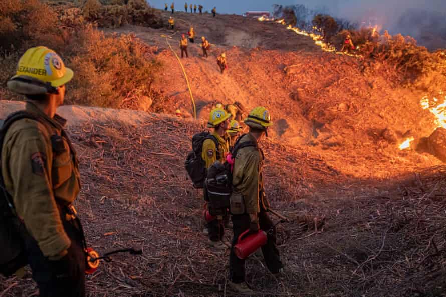
On Saturday, firefighters worked to keep the flames away from structures in Strawberry by running backfire operations and laying down hose line.
Smith said that Strawberry was chosen as an optimal staging area for firefighters to position themselves should the Caldor Fire begin threatening more homes farther east.Play Video
Jumping Highway 50
The Caldor Fire jumped Highway 50 near Kyburz on Saturday, Aug. 21, a day after a 40-mile stretch of the highway between was closed.
The impact of the Caldor Fire could be felt for weeks on Highway 50. The fire has compromised the highway’s safety with unstable trees lining the roadway’s edge. Even after the flames are out, work to assess and remove trees that pose a threat to drivers on that heavily traveled roadway will take time.
“This fire has just simply outpaced us,” said Jeff Marsolais, a forest supervisor for Eldorado National Forest. “We emptied the cupboards of resources, and the local fire chiefs of Amador and El Dorado counties sent every resource they could, and no matter how many folks we try to get on it, it just continued to outpace us.”
U.S. Forest Service officials said that nine national forests will be temporarily closed through Sept. 6 because of extreme fire conditions.
Officials previously announced a complete shutdown of the Eldorado National Forest through Sept. 30 because of the fire, and the Rubicon Trail was closed as well.
| VIDEO BELOW | LiveCopter 3 over the Caldor Fire on Aug. 25, 2021Play Video
| GET THE KCRA 3 APP FOR THE LATEST ALERTS | Apple iOS | Android |
A community almost leveled
The community of Grizzly Flats in El Dorado County, a once wooded area where roughly 1,200 people called home, is hardly recognizable now. The Caldor Fire burned through many of its neighborhoods and businesses, leaving mostly debris.
Deputies with the El Dorado County Sheriff’s Office were dispatched to the Grizzly Flats and Pollock Pines areas to patrol after receiving reports of looting.
Play VideoDuration 1:11See video as flames reach Highway 50 east of Kyburz in Caldor FireThe Caldor Fire burns on both sides of Highway 50 about 10 miles east of Kyburz on Thursday, Aug. 26, 2021, as the fire pushes east prompting evacuation orders all the way to Echo Summit. BY SARA NEVIS
MORE FROM THE SERIES
California Wildfires
The latest on the wildfires burning in California. Get updates on the Dixie Fire, Caldor Fire and others, including size, containment, evacuation orders and more.
EXPAND ALL
We’ve dropped the paywall on this article delivering critical public safety information on this developing story. Please consider a digital subscription to The Sacramento Bee to support local journalists reporting on these wildfires.
Authorities on Thursday expanded evacuations for the Caldor Fire to include the Twin Bridges and Echo Summit areas as the blaze grows closer to the Lake Tahoe Basin.
El Dorado County sheriff’s officials issued new mandatory evacuation orders from Twin Bridges through Echo Summit, extending north of Highway 50 to Flagpole Peak and south of the highway to the Amador-Alpine county line.
The nearly 50-mile Highway 50 closure, which begins at Sly Park Road in Pollock Pines on the west end, has also been extended on the east end.TOP ARTICLES
A small stretch of the highway had previously been open only to residents between Twin Bridges and Meyers, but is now fully closed through Meyers at the Highway 89 junction, as those locals must evacuate. Those evacuating using Highway 50 should head east, emergency officials said in an update.
Evacuation warnings, voluntary at this time, have also been issued for Christmas Valley — a cluster of homes and cabins west of Highway 89 and east of Highway 50 at Echo Summit — and parts of Alpine County, including west of Highway 88 up to Kirkwood.
The Caldor Fire ignited Aug. 14, exploding in size and mostly destroying the town of Grizzly Flats in its first few days. The fire prompted urgent evacuations up through the Pollock Pines, Sly Park and Kyburz area. The fire has spread more slowly but very steadily this week toward the northeast, toward Lake Tahoe.
Cal Fire and the U.S. Forest Service reported the fire Friday morning at 143,951 acres (225 square miles), growing roughly 7,000 acres since Thursday. Officials said containment held at 12% but the fire remained active overnight due to poor humidity recovery.
The city of South Lake Tahoe issued a proclamation of local emergency Thursday due to the Caldor Fire, though there have not yet been formal evacuation orders or warnings within city limits. City officials also gave a warning about tourism at this time.
“Tourists who still plan to come to the Tahoe Basin need to understand that the air quality levels are extremely unhealthy, many of the beaches around the lake are closed, and some businesses have temporarily closed,” the city wrote in a news release.
California Wildfires newsletter
Get the Bee’s latest coverage on wildfires in our state.SIGN UP
Officials at the Lake Valley Fire Protection District, headquartered in South Lake Tahoe, have been on high alert this week.
“To say Lake Valley Fire is concerned is an understatement,” said Brad Zlendick, chief of the fire protection district, during a community meeting Tuesday. “We’re concerned about it affecting our cabins, our homes up on top of Echo Summit.”
The fire is also burning near ski resorts including Sierra-At-Tahoe and Kirkwood.
CALDOR FIRE MAP
Red circles on this live-updating map are actively burning areas, as detected by satellite. Orange circles have burned in the past 12 to 24 hours, and yellow circles have burned within the past 48 hours. Yellow areas represent the fire perimeter. https://maps.nwcg.gov/sa/#/%3F/%3F/38.6617/-120.5628/11Source: National Interagency Fire Center
Eric Ting, SFGATEAug. 25, 2021Updated: Aug. 25, 2021 10:54 a.m.
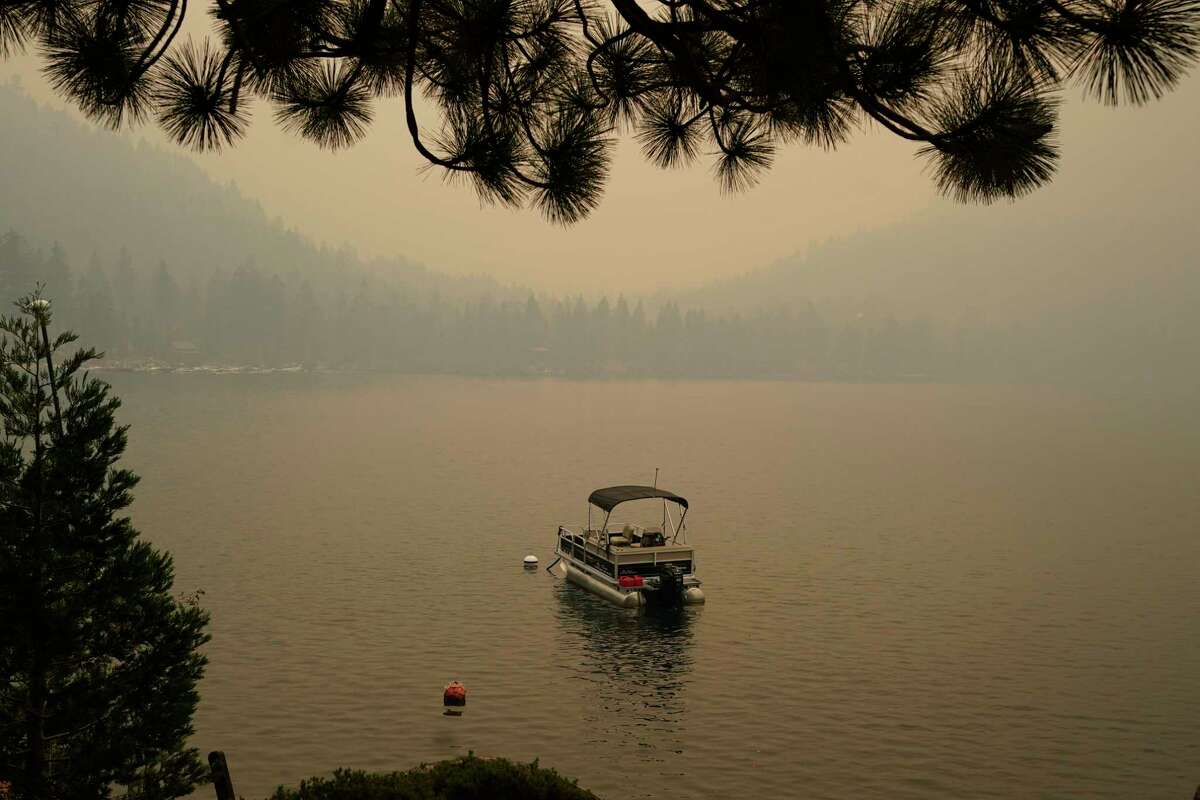
Smoke from the Caldor Fire shrouds Fallen Leaf Lake near South Lake Tahoe, Calif., Tuesday, Aug. 24, 2021. The massive wildfire that is over a week old has scorched more than 190 square miles, and destroyed hundreds of homes since Aug. 14. It is now less than 20 miles from Lake Tahoe.Rich Pedroncelli/AP
During a community briefing Tuesday night, officials said that if the evacuation warning currently in effect in the area near Echo Summit is upgraded to an evacuation order, portions of the South Lake Tahoe region, which includes the city of South Lake Tahoe, will subsequently be placed under an evacuation warning.
“If it goes into an evacuation order, there will be a warning for some portion the South Lake Tahoe basin,” said Sgt. Eric Palmberg of the El Dorado County Sheriff’s Office. “I don’t have the information on where exactly where that will be, but ultimately that will be the trigger.”
The fire is less than 20 miles west of Lake Tahoe, and Palmberg said specifics on where exactly the warning will be in effect will be released when it is appropriate.
“We are in meetings continuously throughout the day assessing the fire and assessing evacuation needs,” he said. “We have systems in place, the entire South Lake Tahoe basin, we have been in discussions with law enforcement, with fire personnel. There is plenty of planning. We’re going to keep the community safe. That is our job, let us worry about it. You’re going to be informed well when it is time to do so.”
Smoke from the fire has choked the Lake Tahoe area, creating some of the worst air the region has experienced. Air quality readings were above 500 this week, which is off the charts for what the Air Quality Index tracks.
Concerns in the towns and resort communities near the famed alpine lake as only 9% of the wildfire has been contained
California’s Caldor fire moves east toward Lake Tahoe as crews continue to battle a blaze that has grown to more than 180 sq miles with only 9% containment. Photograph: Michael Nigro/Pacific Press/Rex/Shutterstock
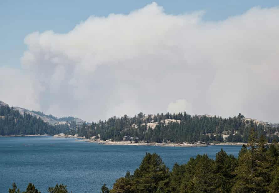
Thousands of firefighters battled on Tuesday to keep a behemoth blaze from surging closer to Lake Tahoe, the blue alpine lake surrounded by resort communities straddling the California-Nevada state line.
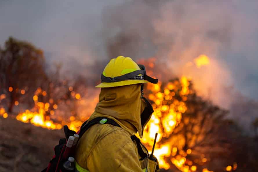
The Caldor fire, just 9% contained, has become the nation’s number one priority for firefighting resources, said Thom Porter, director of the California department of forestry and fire protection.
“It is knocking on the door to the Lake Tahoe basin,” Porter said. “We have all efforts in place to keep it out of the basin but we do need to also be aware that is a possibility based on the way the fires have been burning.”
Porter said he personally did not believe the fire would get into the basin but that he could be proved wrong.
The Caldor fire has already incinerated nearly 180 sq miles (466 sq km) of El Dorado national forest and destroyed more than 630 buildings. More than 17,000 structures were still under threat.
The blaze has exhibited extreme behavior and evaded containment efforts. Now surging through the steep and rugged terrain, officials are fighting to keep the flames out of communities tucked into the conifer-covered canyons.
Smoke from the Caldor fire hovers over Caples Lake in Kirkwood, California. Photograph: Fred Greaves/Reuters
Smoke on Monday forced the closure of public schools in parts of the Lake Tahoe area and across the state border with Nevada in the Reno and Sparks area. The air quality remained hazardous throughout the region on Tuesday, extending into the Sacramento area, with the Tahoe area measuring above 300 on the Air Quality Index.
The fire is also hugging Highway 50, now closed in both directions, cutting off a primary thoroughfare between South Lake Tahoe and Sacramento.
Weather conditions, however, were offering good news, Porter said. Low to moderate fire weather farther south assured officials that it was safe to deploy more resources to the fires in the north. Throughout the state, mild temperatures have lowered the risk of new ignitions.
Still, Porter cautioned, for the fires already burning, big battles lay ahead. “They are going to continue to grow and get bigger,” Porter said, calling the siege a marathon.
California is only halfway through what’s typically considered fire season, a period that is encroaching on months once considered safe. Porter noted the need to give firefighters breaks and time to reset, before they “continue the fight into the deep fall”.
“These are our days,” Porter said, a nod to the annual emergencies fires inflict on areas across the west. “Every year we need to be ready for this type of activity.” He noted that this year California has seen nearly three times the amount of average over the five-year average.
Fueled by parched vegetation and hot, dry conditions, the fires’ intensity is directly attributable to climate change. Nearly half of the contiguous US is mired in drought and more than 88% of California is classified in extreme drought by the US Drought Monitor. Extreme heatwaves that set records through the region this summer have intensified the conditions and set the stage for the big blazes now burning.
The Caldor fire is just one of a dozen large wildfires raging across California with months left before winter rains are expected to bring relief.
The Dixie fire, which has burned more than 1,130 sq miles in the northern Sierra Nevada and southern Cascades, by Monday evening was 40% contained.
The Caldor fire is just one of a dozen large wildfires raging across California. Photograph: Michael Nigro/Pacific Press/Rex/Shutterstock
The California governor, Gavin Newsom, on Monday requested a presidential major disaster declaration for eight counties, Mark Ghilarducci, director of the California office of emergency services, told a briefing near Sacramento.
If approved, the declaration would provide a wide range of assistance including housing, food aid, unemployment and governmental emergency costs, Ghilarducci said.
Nearly 43,000 Californians were under evacuation orders and more than 500 households were in shelters, he said.
While southern California has so far escaped large scale wildfires this year, Los Angeles officials on Monday urged residents to be aware of what’s going on in the north because the region’s high fire season is typically late in the year when dry, gusty Santa Ana winds blast out of the interior and flow toward the coast.
“That awareness is going to help us when it happens here in southern California,” the Los Angeles fire chief, Ralph Terrazas, said during a briefing. The mix of spring growth dried out by summer heat and high winds creates “a dangerous condition that could lead to large, fast-moving brush fires”, he said.
California’s fires were among more than 90 large, active blazes in the US, according to the National Interagency Fire Center in Boise, Idaho.
“Every Californian needs to be ready,” Porter said, advising residents of the state to begin preparing a go-bag with essentials now. “Be ready for the emergency that is coming to your doorstep,” he said. “And when it’s time to go – just go.”


 Updated: 1:40 PM PDT Aug 30, 2021Infinite Scroll Enabled