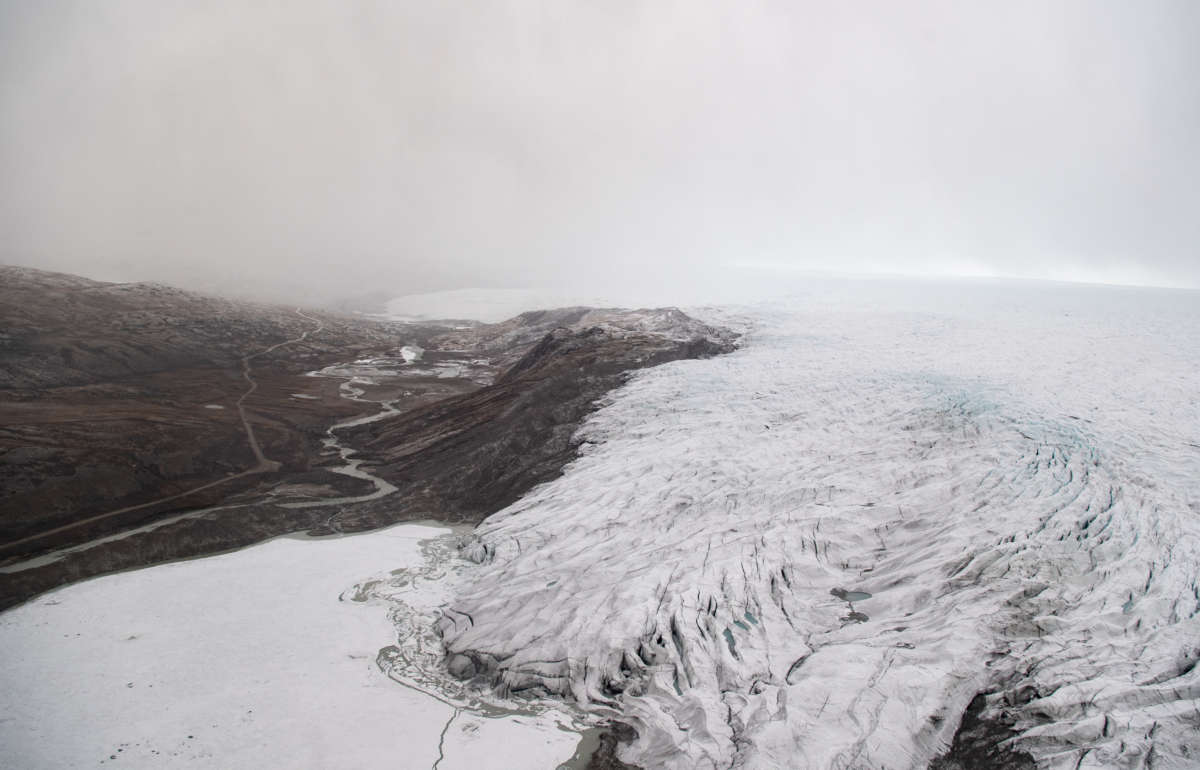
An edge of the retreating Greenland Ice Sheet is viewed at ‘Point 660’, located 660 meters above sea level, on September 8, 2021 near Kangerlussuaq, Greenland. 2021 will mark one of the biggest ice melt years for Greenland in recorded history.
Greenland’s ice sheet, the biggest ice sheet in the world behind Antarctica, has melted so much in the past decade that global sea levels rose by 1 centimeter, and trends predict sea levels can rise nearly a foot higher by the end of the century.
Research published in the journal Nature Communications on Monday says 3.5 trillion tons of Greenland’s ice sheet melted from 2011 to 2020, which would be enough to flood all of New York City in 14,700 feet of water.
The ice sheet covers more than 656,000 square miles, and if it were to fully melt, the global sea level would rise about 20 feet, according to the National Snow and Ice Date Center. While much of the ice sheet remains intact, researchers from the University of Leeds Centre for Polar Observation and Modelling in Northern England found it is melting at an exceptional rate, increasing 21% in the past 40 years.
“Observations show that extreme melt events in Greenland have become more frequent and more intense – as well as more erratic – which is a global problem,” Lin Gilbert, co-author of the study, said in a statement.
An edge of the retreating Greenland Ice Sheet is viewed at ‘Point 660’, located 660 meters above sea level, on September 8, 2021 near Kangerlussuaq, Greenland. 2021 will mark one of the biggest ice melt years for Greenland in recorded history.
The team used satellite data from the European Space Agency to estimate the elevation of the ice sheet, the first time a space object has been used to do so. The team found that from 2011 to 2020, the runoff of Greenland’s ice sheet averaged about 357 billion tons a year.
That would, on average, raise the global sea level about 1 millimeter a year, but during that time, two years – 2012 and 2019 – experienced exceptionally more runoff than others as extreme weather led to, “record-breaking levels of ice melting.” In 2019, the runoff was about 527 billion tons.
As the polar ice sheets melt, the process is not just raising sea levels – it’s also warping the underlying surface of Earth, a new study reveals, and some of the effects can be seen across thousands of miles.
What’s happening is that Earth’s crust is rising and spreading as the weight of the ice across Greenland, Antarctica, and the Arctic Islands gets lifted. The movement isn’t huge, averaging less than a millimeter a year, but it’s there and it covers a lot of ground.
There’s a feedback loop happening too, because as the bedrock under the ice shifts, that in turn affects how the ice continues to melt and break away. A full understanding of how this works is essential in modeling how our world might look in the future.
“Scientists have done a lot of work directly beneath ice sheets and glaciers,” says geophysicist Sophie Coulson, from Los Alamos National Laboratory in New Mexico.
“So they knew that it would define the region where the glaciers are, but they hadn’t realized that it was global in scale.”
In some areas, the horizontal movement actually exceeds the vertical movement, the researchers found. They used satellite data and field measurements covering the years 2003 to 2018 to measure crust movement in three dimensions.
These crust rebounds can actually take thousands of years – the study notes that some changes are still being felt across Earth’s surface from the end of the last ice age, some 11,000 years ago.
“On recent timescales, we think of Earth as an elastic structure, like a rubber band, whereas on timescales of thousands of years, Earth acts more like a very slow-moving fluid,” says Coulson.
“Ice age processes take a really, really long time to play out, and therefore we can still see the results of them today.”
The researchers compare the effect of the ice pack to a wooden board being pushed down on water: when the board is removed, and the weight is gone, the liquid expands to fill the available space, and the same happens with Earth’s crust.
And with the rate of ice melt continuing to increase across the globe, it’s important that scientists are able to figure out what impact it’s having on the shape of Earth’s surface, even if the shifts are relatively small each year.
This new study gives us more detailed data on what’s happening than we’ve ever had before – and that’s useful not just for studying melting ice and shifts in the Earth’s shape, but also for many other fields of scientific study.
“Understanding all of the factors that cause movement of the crust is really important for a wide range of Earth science problems,” says Coulson.
“For example, to accurately observe tectonic motions and earthquake activity, we need to be able to separate out this motion generated by modern-day ice-mass loss.”
This past weekend, researchers at the National Science Foundation’s Summit Station observed rainfall at the peak of Greenland’s rapidly melting ice sheet for the first time on record — an event driven by warming temperatures.
“This was the third time in less than a decade, and the latest date in the year on record, that the National Science Foundation’s Summit Station had above-freezing temperatures and wet snow,” the National Snow and Ice Data Center (NSIDC) said in a press release earlier this week. “There is no previous report of rainfall at this location (72.58°N 38.46°W), which reaches 3,216 meters (10,551 feet) in elevation.”
Temperatures at the summit of the ice sheet rose above freezing at around 5:00 am local time on Saturday, “and the rain event began at the same time,” NSIDC noted. “For the next several hours, rain fell and water droplets were seen on surfaces near the camp as reported by on-station observers.”
Uncompromised, uncompromising news
Get reliable, independent news and commentary delivered to your inbox every day.
Email
The anomalous rainfall at the ice sheet’s peak marked the start of a three-day period during which “above-freezing temperatures and rainfall were widespread to the south and west of Greenland … with exceptional readings from several remote weather stations in the area,” said NSIDC. “Total rainfall on the ice sheet was 7 billion tons.”
The warmer-than-usual temperatures caused significant melting of the ice sheet, with melt extent peaking at 337,000 square miles on August 14.
“Warm conditions and the late-season timing of the three-day melt event coupled with the rainfall led to both high melting and high runoff volumes to the ocean,” NSIDC observed. “On August 15 2021, the surface mass lost was seven times above the mid-August average … At this point in the season, large areas of bare ice exist along much of the southwestern and northern coastal areas, with no ability to absorb the melt or rainfall. Therefore, the accumulated water on the surface flows downhill and eventually into the ocean.”https://platform.twitter.com/embed/Tweet.html?dnt=false&embedId=twitter-widget-0&features=eyJ0ZndfZXhwZXJpbWVudHNfY29va2llX2V4cGlyYXRpb24iOnsiYnVja2V0IjoxMjA5NjAwLCJ2ZXJzaW9uIjpudWxsfSwidGZ3X2hvcml6b25fdHdlZXRfZW1iZWRfOTU1NSI6eyJidWNrZXQiOiJodGUiLCJ2ZXJzaW9uIjpudWxsfSwidGZ3X3NwYWNlX2NhcmQiOnsiYnVja2V0Ijoib2ZmIiwidmVyc2lvbiI6bnVsbH19&frame=false&hideCard=false&hideThread=false&id=1428115699084390402&lang=en&origin=https%3A%2F%2Fwww.commondreams.org%2Fnews%2F2021%2F08%2F20%2Frainfall-observed-peak-greenland-ice-sheet-first-time-record&sessionId=675bdad0c5dbc1af18daa22c7114625603c808b5&siteScreenName=truthout&theme=light&widgetsVersion=1890d59c%3A1627936082797&width=550px
Ted Scambos, a senior research scientist at the Cooperative Institute for Research in Environmental Sciences at the University of Colorado at Boulder, toldThe Washington Post on Thursday that while the three-day melting event “by itself does not have a huge impact,” it is “indicative of the increasing extent, duration, and intensity of melting on Greenland.”
“Like the heat wave in the [U.S. Pacific] northwest, it’s something that’s hard to imagine without the influence of global climate change,” said Scambos. “Greenland, like the rest of the world, is changing. We now see three melting events in a decade in Greenland — and before 1990, that happened about once every 150 years. And now rainfall: in an area where rain never fell.”
In a landmark report released earlier this month, the Intergovernmental Panel on Climate Change (IPCC) concluded that “it is very likely that human influence has contributed to the observed surface melting of the Greenland ice sheet over the past two decades.”
In July — which the National Oceanic and Atmospheric Administration recently deemed the hottest month ever recorded on Earth — a heat wave in Greenland caused enough melting to cover the entire state of Florida with two inches of water.
“What is going on is not simply a warm decade or two in a wandering climate pattern,” Scambos toldCNN in response to the rainfall at the ice sheet’s summit. “This is unprecedented.”
By Mark Kinver Environment reporterPublished1 day agoShare
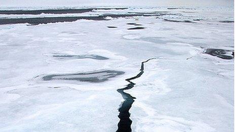
In our monthly feature, Then and Now, we reveal some of the ways that planet Earth has been changing against the backdrop of a warming world. The shrinking sea-ice in the Arctic is not only a sign of climate change, it is causing the planet to warm more quickly. This is because more sunlight is being absorbed by the darker ocean, rather than being reflected back into space.https://flo.uri.sh/visualisation/6397277/embed?auto=1
Arctic sea-ice plays an important role in controlling the planet’s temperature, and any problem with this natural thermostat is a cause for concern.
Figures from the US space agency (Nasa) suggest the loss of the minimum Arctic sea-ice extent is in the region of 13.1% per decade, based on the 1981 to 2010 average.
A major report on climate change in 2007 linked the growing concentration of greenhouse gases in the atmosphere, caused by human activity, with declining sea-ice extent in the region.
The disappearance of the sea-ice in a warming world also contributes to rising average surface temperatures. The sea-ice is estimated to reflect 80% of sunlight back into space, meaning it does not warm the surface.
But when the sea-ice has melted, the darker ocean surface is exposed, which absorbs about 90% of the sunlight hitting it. This results in warming of the region.
This phenomenon is known as the Albedo effect, and it occurs because light surfaces reflect more heat than dark surfaces.
The freezing and thawing of the ocean in the Arctic is a seasonal occurrence, with the freezing peaking in March and the melting reaching its maximum in September.
image captionData suggests that the extent of Arctic sea-ice is shrinking by 13% each decade as the world warms
However, data from on-the-ground observations and from satellites tell us that the extent of sea-ice in the Arctic polar region is declining as the planet warms.
As this occurs, the albedo (or reflectivity) is reduced, because the dark ocean waters absorb more heat than the lighter sea-ice. This in turn causes the land and oceans to warm even more.
Ultimately, scientists fear, the increasing amount of ground being exposed in regions traditionally covered with snow will trigger a “tipping point”. This is where the warming of the atmosphere reaches a point where human interventions will no longer be able to halt it.
Smaller and warmer world
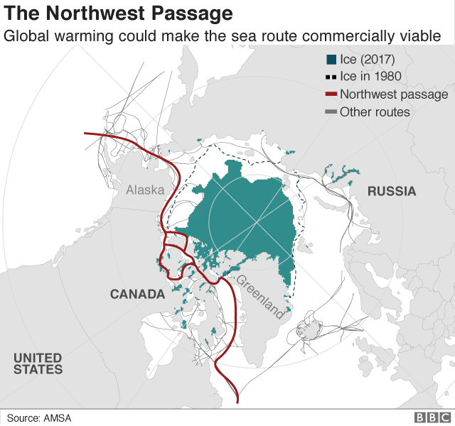
Another impact of the decreasing density of ice in the northern polar region is the opening of the Northwest Passage. This trading route links the North Atlantic Ocean with the North Pacific Ocean.
Since the 19th Century, there has been clamour to find a navigable route through frozen Arctic waters between Greenland and Canada’s Arctic islands.
It has long been a deadly pursuit for mariners who braved the frozen seascape. However, some experts estimate that the route will become commercially viable in the near future as the sea-ice retreats in the summer months.
For some, it is going to revolutionise the global shipping sector. For others, it is a disaster waiting to happen.
Environmental groups fear a growing volume of shipping traffic through the pristine Arctic waters will damage slow-growing, long-lived marine ecosystems.
They particularly fear a ship encountering a mishap in the remote polar waters, resulting in a potentially devastating pollution incident.
Lack of food
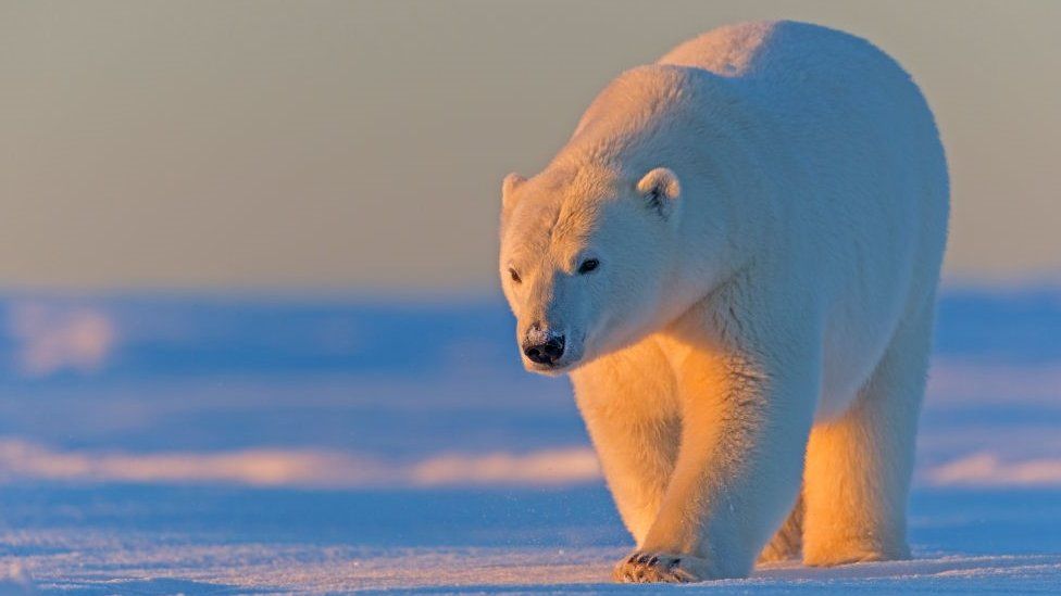
Evidence suggests that the thinning sea-ice is affecting wildlife, including top-of-the-food-chain predators such as polar bears. The ice is not strong enough to support the animals’ weight, forcing them to embark on energy-sapping swims and making it more difficult to catch prey.
image captionStudies show that polar bears are struggling to hunt on the melting sea-ice during summer months
As well as causing starvation, it is also reportedly resulting in bears coming into human settlements looking for food.
Another concern among scientists is that melting sea-ice is affecting a major ocean current in the Arctic – the Beaufort Gyre.
Freshwater is less dense than salty seawater. The researchers said a sudden influx of freshwater from the Arctic Ocean into the northern Atlantic Ocean could alter the strength of the current.
This is because the force pushing water down the eastern coast of continental North America will be reduced, resulting in a smaller volume of warmer tropic waters from equatorial regions being displaced towards western Europe.
Models suggest the reduction in warmer waters heading towards western Europe will result in lower temperatures in the region. This, in turn, would also affect weather patterns in the global climate system.
Our Planet Then and Now will continue each month up to the UN climate summit in Glasgow, which is scheduled to start in November 2021
First global assessment of the extent of snow and ice cover on Earth’s surface—a critical factor cooling the planet through reflected sunlight—and its response to warming temperatures.
The global cryosphere—all of the areas with frozen water on Earth—shrank by about 87,000 square kilometers (about 33,000 square miles), a area about the size of Lake Superior, per year on average, between 1979 and 2016 as a result of climate change, according to a new study. This research is the first to make a global estimate of the surface area of the Earth covered by sea ice, snow cover, and frozen ground.
The extent of land covered by frozen water is just as important as its mass because the bright white surface reflects sunlight so effectively, cooling the planet. Changes in the size or location of ice and snow can alter air temperatures, change the sea level and even affect ocean currents worldwide.
The new study is published in Earth’s Future, AGU’s journal for interdisciplinary research on the past, present, and future of our planet and its inhabitants.
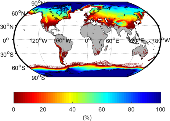
The percentage of each area that experiences ice, snow or frozen ground at some point during the year (1981-2010). Credit: Peng et al. (2021) Earth’s Future https://doi.org/10.1029/2020EF001969
“The cryosphere is one of the most sensitive climate indicators and the first one to demonstrate a changing world,” said first author Xiaoqing Peng, a physical geographer at Lanzhou University. “Its change in size represents a major global change, rather than a regional or local issue.”
The cryosphere holds almost three-quarters of Earth’s fresh water, and in some mountainous regions, dwindling glaciers threaten drinking water supplies. Many scientists have documented shrinking ice sheets, dwindling snow cover, and loss of Arctic sea ice individually due to climate change. But no previous study has considered the entire extent of the cryosphere over Earth’s surface and its response to warming temperatures.
Contraction in space and time
Peng and his co-authors from Lanzhou University calculated the daily extent of the cryosphere and averaged those values to come up with yearly estimates. While the extent of the cryosphere grows and shrinks with the seasons, they found that the average area covered by Earth’s cryosphere has contracted overall since 1979, correlating with rising air temperatures.
The shrinkage primarily occurred in the Northern Hemisphere, with a loss of about 102,000 square kilometers (about 39,300 square miles), or about half the size of Kansas, each year. Those losses are offset slightly by growth in the Southern Hemisphere, where the cryosphere expanded by about 14,000 square kilometers (5,400 square miles) annually. This growth mainly occurred in the sea ice in the Ross Sea around Antarctica, likely due to patterns of wind and ocean currents and the addition of cold meltwater from Antarctic ice sheets.
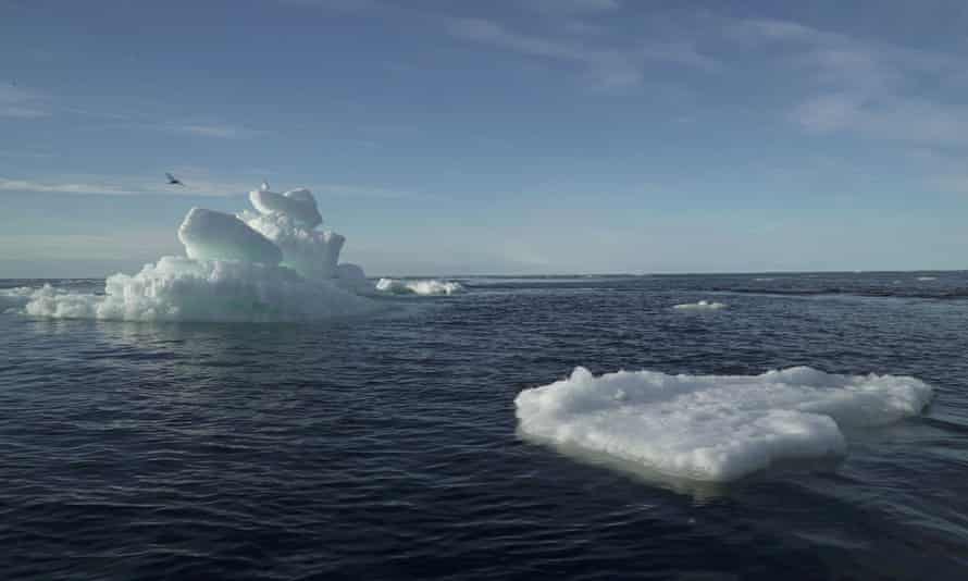
Sea ice melting in the Arctic Ocean. Credit: NASA/Kathryn Hansen
The estimates showed that not only was the global cryosphere shrinking but that many regions remained frozen for less time. The average first day of freezing now occurs about 3.6 days later than in 1979, and the ice thaws about 5.7 days earlier.
“This kind of analysis is a nice idea for a global index or indicator of climate change,” said Shawn Marshall, a glaciologist at the University of Calgary, who was not involved in the study. He thinks that a natural next step would be to use these data to examine when ice and snow cover give Earth its peak brightness, to see how changes in albedo impact the climate on a seasonal or monthly basis and how this is changing over time.
To compile their global estimate of the extent of the cryosphere, the authors divided up the planet’s surface into a grid system. They used existing data sets of global sea ice extent, snow cover, and frozen soil to classify each cell in the grid as part of the cryosphere if it contained at least one of the three components. Then they estimated the extent of the cryosphere on a daily, monthly, and yearly basis and examined how it changed over the 37 years of their study.
The authors say that the global dataset can now be used to further probe the impact of climate change on the cryosphere, and how these changes impact ecosystems, carbon exchange, and the timing of plant and animal life cycles.
Reference: “A Holistic Assessment of 1979–2016 Global Cryospheric Extent” by Xiaoqing Peng, Tingjun Zhang, Oliver W. Frauenfeld, Ran Du, Haodong Jin and Cuicui Mu, 16 May 2021, Earth’s Future. DOI: 10.1029/2020EF001969
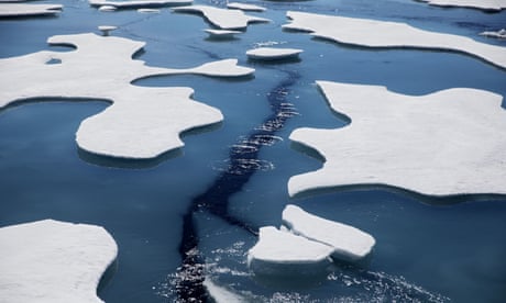
Sea ice across much of the Arctic is thinning twice as fast as previously thought, researchers have found.
Arctic ice is melting as the climate crisis drives up temperatures, resulting in a vicious circle in which more dark water is exposed to the sun’s heat, leading to even more heating of the planet.
The faster ice loss means the shorter north-eastern shipping passage from China to Europe will become easier to navigate, but it also means new oil and gas extraction is more feasible.
Calculating the thickness of sea ice from satellite radar data is difficult because the amount of snow cover on top varies significantly. Until now, the snow data used came from measurements by Soviet expeditions on ice floes between 1954 and 1991. But the climate crisis has drastically changed the Arctic, meaning this information is out of date.
The new research used novel computer models to produce detailed snow cover estimates from 2002 to 2018. The models tracked temperature, snowfall and ice floe movement to assess the accumulation of snow. Using this data to calculate sea ice thickness showed it is thinning twice as fast as previously estimated in the seas around the central Arctic, which make up the bulk of the polar region.
Robbie Mallett of University College London, who led the study, said: “Sea ice thickness is a sensitive indicator of the health of the Arctic – and, when the Arctic warms, the world warms.
“Thicker ice acts as an insulating blanket, stopping the ocean from warming up the atmosphere in winter and protecting the ocean from the sunshine in summer. Thinner ice is also less likely to survive during the Arctic summer melt.”
Changes in the Arctic are also increasingly believed to influence extreme weather such as heatwaves and floods around the northern hemisphere. The rapid thinning of sea ice has consequences for human activities in the Arctic as well.
The newly exposed waters enabled storms to hit coastal communities and erode coasts, Mallett said. The opening of the shorter north-eastern shipping route around Siberia means less fuel is needed to transport goods between China and Europe, leading to lower carbon emissions.Advertisementhttps://1800dead54a5b54ff32446a37838d191.safeframe.googlesyndication.com/safeframe/1-0-38/html/container.html
In February, a cargo ship made a round trip for the first time in winter. “However, this also raises the risk of fuel spillages in the Arctic, the consequences of which could be dire,” said Mallett.
“There’s also a lot of interest in oil and gas extraction from the Russian shelf seas,” Mallett said. But the research revealed much greater annual variability in ice thickness than estimated before. “Knowing the thickness of the ice is pretty critical to planning those activities, so the enhanced variability is generally bad news for those planning to work in the Arctic,” he said.
The Soviet-era data was hard won, Mallett said. “They sent these brave guys out and they sat on these drifting stations and floated around the Arctic, sometimes for years at a time, measuring the snow depth.” But the Intergovernmental Panel on Climate Change identified the lack of more recent data as a key knowledge gap in 2019.
Sea ice thickness is calculated from satellite radar data that measures how high the ice sits above the sea surface. Snow on top of the ice is invisible to the radar signals but it weighs the ice down, so it is critical to know the depth of snow.
“Sea ice has begun forming later and later in the year, so the snow on top has less time to accumulate,” said Mallett. “Our calculations account for this declining snow depth for the first time.” The research is published in the journal The Cryosphere.
“We are still learning about the changes to the Arctic environment, and one of the big unknowns – or less well-knowns – is snow cover,” said Walt Meier, at the US National Snow and Ice Data Center, and not involved in the new research. “The approach in the study is a significant improvement over older methods, and the results fit with other changes we’re seeing with Arctic sea ice, including earlier melt onset, lower summer ice cover, and later freeze-up.”
Prof Julienne Stroeve, at UCL, said: “There are [still] a number of uncertainties but we believe our new calculations are a major step forward. We hope this work can be used to improve climate models that forecast the effects of long-term climate change in the Arctic – a region that is warming at three times the global rate and whose ice is essential for keeping the planet cool.”
by Maja Sojtaric, UiT The Arctic University of Norway
The Finnish Meteorological Institute’s observation station used in the study, Pallas National Park, Arctic Finland. Credit: Jeff Welker
They are diligently stoking thousands of bonfires on the ground close to their crops, but the French winemakers are fighting a losing battle. An above-average warm spell at the end of March has been followed by days of extreme frost, destroying the vines with losses amounting to 90 percent above average. The image of the struggle may well be the most depressingly beautiful illustration of the complexities and unpredictability of global climate warming. It is also an agricultural disaster from Bordeaux to Champagne.https://e1ac7464d9e81ce2033a0fae7f811a32.safeframe.googlesyndication.com/safeframe/1-0-38/html/container.html
It is the loss of the Arctic sea-ice due to climate warming that has, somewhat paradoxically, been implicated with severe cold and snowy mid-latitude winters.
“Climate change doesn’t always manifest in the most obvious ways. It’s easy to extrapolate models to show that winters are getting warmer and to forecast a virtually snow-free future in Europe, but our most recent study shows that is too simplistic. We should beware of making broad sweeping statements about the impacts of climate change.” Says professor Alun Hubbard from CAGE Center for Arctic Gas Hydrate, Environment and Climate at UiT The Arctic University of Norway.
Melting Arctic sea ice supplied 88% of the fresh snow
Hubbard is the co-author of a study in Nature Geoscience examining this counter-intuitive climatic paradox: A 50% reduction in Arctic sea-ice cover has increased open-water and winter evaporation to fuel more extreme snowfall further south across Europe.
The study, led by Dr. Hanna Bailey at the University of Oulu, Finland, has more specifically found that the long-term decline of Arctic sea-ice since the late 1970s had a direct connection to one specific weather event: “Beast from the East”—the February snowfall that brought large parts of the European continent to a halt in 2018, causing £1bn a day in losses.
Researchers discovered that atmospheric vapor traveling south from the Arctic carried a unique geochemical fingerprint, revealing that its source was the warm, open-water surface of the Barents Sea, part of the Arctic Ocean between Norway, Russia, and Svalbard. They found that during the “Beast from the East,” open-water conditions in the Barents Sea supplied up to 88% of the corresponding fresh snow that fell over Europe.
Professor Alun Hubbard downloading information from an Automatic Weather Station in the Barents Sea. Credit: Alun Hubbard
Climate warming is lifting the lid off the Arctic Ocean
“What we’re finding is that sea-ice is effectively a lid on the ocean. And with its long-term reduction across the Arctic, we’re seeing increasing amounts of moisture enter the atmosphere during winter, which directly impacts our weather further south, causing extreme heavy snowfalls. It might seem counter-intuitive, but nature is complex and what happens in the Arctic doesn’t stay in the Arctic.” says Bailey.
When analyzing the long-term trends from 1979 onwards, researchers found that for every square meter of winter sea-ice lost from the Barents Sea, there was a corresponding 70 kg increase in the evaporation, moisture, and snow falling over Europe.
The Beast from the East on March 15, 2018, captured by Aqua MODIS satellite imagery. The parallel cloud bands (“cloud streets”) streaking south across the Barents Sea indicate convection rolls of warm, moist air rising from the ice-free surface. Credit: NASA
Their findings indicate that within the next 60 years, a predicted ice-free Barents Sea will likely become a significant source of increased winter precipitation—be it rain or snow—for Europe.
“This study illustrates that the abrupt changes being witnessed across the Arctic now, really are affecting the entire planet,” says professor Hubbard.
(CNN)Russia is amassing unprecedented military might in the Arctic and testing its newest weapons in a region freshly ice-free due to the climate emergency, in a bid to secure its northern coast and open up a key shipping route from Asia to Europe.Weapons experts and Western officials have expressed particular concern about one Russian ‘super-weapon,’ the Poseidon 2M39 torpedo. Development of the torpedo is moving fast with Russian President Vladimir Putin requesting an update on a “key stage” of the tests in February from his defense minister Sergei Shoigu, with further tests planned this year, according to multiple reports in state media.
Melting permafrost offers opportunities but poses calamitous risks
An LNG tanker successfully sailed to Asia via the Arctic Ocean early this year, the first time the journey has been managed in winter. (Kyodo photo/courtesy of Sovcomflot)KO SAKAI, Nikkei senior staff writerMarch 14, 2021 09:56 JST
TOKYO — On Feb. 19, a Russian icebreaker that transports liquefied natural gas arrived at Sabetta, an LNG loading port in the far north of Siberia. The ship had sailed through the ice-covered Arctic Ocean on its way to and back from China’s Jiangsu Province.
The journey is noteworthy because the Arctic Sea route that the ship took is usually only navigable from July to November, when the sea ice is thin.
It was the first time for a ship to successfully navigate the Arctic Sea route to Asia in the dead of winter.
Japanese companies took note. JGC Holdings has built an LNG plant near the port, to and from which Mitsui O.S.K. Lines partially handles transportation. Trading house Mitsui & Co. and other parties have invested in the second phase of the LNG project, which is to be completed around 2023. Once a year-round shipping route is established, transportation time between Russia and Japan will be greatly reduced.
Global warming is something of a boon for Russia, where 55% to 65% of the country is covered in permafrost. It is estimated that 60% of the country’s oil and 90% of its natural gas, as well as deposits of nonferrous metals and gold, lie under this thawing part of the planet.
President Vladimir Putin once shrugged off the perils of global warming, saying, “an increase of two or three degrees wouldn’t be so bad for a northern country like Russia. We could spend less on fur coats, and the grain harvest would go up.”
That was at least partially prophetic. According to Russia’s Federal State Statistics Service, grain production in 2020 was up 9.7% from the previous year, the second highest level after 2017. The amount of land under cultivation is also increasing.
But those shrugged-off perils are beginning to overshadow the bumper harvests.
In the Republic of Sakha in far eastern Siberia, the temperature is minus 50 C, yet white smoke rises from the snow-covered ground. In January, local media released an amazing image of a peat fire in the ground under the snow.
Roughly 140,000 sq. km of Russia, about the size of Greece, was lost to fire in 2020. Most of that was in once-frozen areas. When covered with snow in winter, the fires seem to be extinguished. However, the peat in the ground continues to smolder, and in summer it ignites on the surface. They’re being called zombie fires and are believed to be caused by global warming.
There are concerns that the zombies will rage again this year.
Peat fires emit large amounts of carbon dioxide. A record 244 million tons of CO2 equivalents were released by fires near the Arctic Circle, mainly in Russia, in the 12 months through last August, according to the British journal Nature. That is 35% more than a year earlier and equal to 21% of Japan’s total emissions in 2017.
In Siberia, plants and other organisms that have been decomposing for more than 10,000 years are trapped in the soil as CO2 and methane gas. These gases are released by fires and other events, further accelerating global warming. The world’s permafrost zones are thought to contain twice the amount of carbon that is in the atmosphere.The Yamal Peninsula in the Russian Arctic in summer 2020. Seventeen of these holes have been discovered since 2014. (Kyodo photo/courtesy of Russian researchers)
There is another phenomenon that illustrates the seriousness of the situation.
Last summer a craterlike hole with a diameter of 20 meters and depth of 30 meters was discovered in the permafrost zone of northwestern Siberia. It is the 17th such hole to be discovered since 2014. The working hypothesis is that the craters are the result of explosions of accumulated methane gas in the thawing permafrost. The blasts are able to blow away frozen soil that had been contained by ice.
This might be fine so long as no one is living in these locations. But in May 2020, a fuel tank at a power plant on the outskirts of the city of Norilsk in central Siberia collapsed, spilling diesel fuel into a nearby river. It caused such serious environmental damage that Putin declared a state of emergency.
The operating company concluded that the collapse occurred because the ground loosened as the permafrost thawed. It has been reported that one-fifth of the infrastructure in the frozen zone, including oil and gas facilities as well as railroads, will be affected by 2050.
In 2016, western Siberia experienced a different kind of crisis, an anthrax outbreak. One boy and over 2,000 reindeer died. The source of the bacterial infections was the melted corpse of a reindeer that had been frozen for more than 75 years. Some scientists have warned of the possibility of more dormant pathogens reactivating.
Russia ratified the Paris Agreement in September 2019. The base year for reducing greenhouse gas emissions is 1990, just before the collapse of the Soviet Union. Since its emissions have declined rapidly since then, Russia has already met its short-term target.
Although it was supposed to be a global warming “winner,” Russia has become an unexpected climate change victim.
The anomalies in Siberia are a wake-up call from Mother Earth. It is time for all of humanity to listen, and for all of us to pool our collective wisdom to address this problem.
FEBRUARY 23, 2021 / 10:33 AM / CBS NEWShttps://www.cbsnews.com/embed/video/?v=90e7edd0f15ac3c6b9d88895f2cc4fde#xVZZb9w2EP4rgh4L06JuaYGisJsCTZumhp08FN5gwWO0y5o6Skp7IPB%2F71DS7tpu0CAB0sIwlqLm%2FGbmG3302dC3nWYHf9GbAS78rZLQ%2BouPvuqhtv7i%2FqPfHzrwF%2F62lf6FryQeK8l4GlcpSWRUkgTwVFaxJGlOqwKSgoeCoWzd7W%2Bheu00HviN4lv9182r1wf4vWyu1S%2B3v5XFH4dd%2FjM1byxKWz2sUdKABWbEBowlom2EHiQQzcwabE%2FwRa8EgX0HUvWqbVCvV7128d2eFb1KNcpuvFnNuxrVvGdqEh5QCQ%2FVoPWnbByd%2F6sVwZq2UYLpd19roVc1vmJ15y%2FCjKZZlCR5SinFCAfDRqFFRNPz4xvGQaMnGi%2BiFA3o6bnBNLA8NUNPrn7Wwb7p%2B84ulsEyENw2sLPxJR4U%2BsM4LkVbL4PNwJeBWgZmGUQ0ossgDPE%2FXwZJWVBgIiRJlEusdJaRIg5LElYx41Ums4qiZr8Zat4wpZdBltB9nKGFJC0qWYlYVHkIBU9Zjr3CoRIp4wXl%2BRQNqQaL6ZAvKzg5OSRpUeZJSWa3l392a0Rj88m0o2%2BYdhgVdJ87EyyLKeM0FWkqYxlmBZOQ5YngOeNZGolvl%2Ffjhd8Z2CrYvTf6GQC200rAJav1%2BlK1GGOHSW8j%2FHeDvgw%2BN5jLYDa8DPwTOzyx35lWXiI1jG8uZ7gniOcHdIUgb7R9iXRYRDQvaBaGRYYBjWnlq1GwZrYHc1nHQ3H0Gv3nbqvW1KxHt6xzII7Dtwz2pO5g%2Ff72DUoML8De7XbPY5lB%2FrJSj0gr%2B7ruWheOv6iYtkjNSNRKjNTserxgcS6ylBPBZUISLjjhVGak4q59o7wM8%2BLMqi4qNx0KjAsE6f5%2BuvuAncMMNP07Z%2F0tqx2J%2FXh99%2Fap9PVhenE%2FvfmA7Qadsq3EuxB9ALOOpvzQOYR1jeamF0OH3WPtKQWm9ZUQeHOtW%2FFwIi373oK5G7gVRnGQJ3HbtY1tzVFuA%2FurV1CxQbuq0Av888fb6%2FNtXF4k6UVaOmY1TDyoZu0gw2pY0RoYz9hKMaUpLTIk8GTOd66Z4%2FQMr75zLvGhsSvbr9YOFVfW6YZ1K%2BbyfbsMrvxHRKMe9jem7cD0h18BwfWjJAfJ0iwOcxmmSZmUYRTHLM78R0S8hp6NHI0h9rA%2BuDPebVo5dRs0cjQ7F68C1g8GJBFuBYBbw%2FNOxoARIgf3eQ%2FiEYccD6f2229wEkSrNYipv05qy%2BCl7WXwg7Ir3a7XIFeq%2BZ46bnmKpLI%2FNYxrV6Xpi4EZbF8NVwPGb9yyv%2FdplcqwhISwqkQiLStJiohTZK4wyQueMZ7nrvOeqR5bjGnYs0Ya5rXy0LRb9kRy%2FJaQVZZFgoeEyrwiSZ5JUkaiIJJTniRFEUeV6%2FxZ5WbgrzAxVxMaoU5EotgL00UcL5LoLHbc32awVrHG61nzAMYTQ2895o0c2A5WHzzlxtIqRMDrWL%2Fx%2Bo1ph7X7BW%2FHTI0wedNIPzF%2BrFbTI%2Bir%2Bda12qkoM3AZoxnNOIEoxa%2BrMkwRwpCTCPKoFEWMa7VycJz1jqgJjau%2FB09sWIPd%2BsF94GyR%2BWfXEuwD8sdILK9g69Dw3eSvjwKuuVfum8%2BNMP7%2BrBzz3Pu71mjpzLnLu8knik%2FX0%2B1sAQfdjavaIg7A%2FZmvxoplNE%2BrhBYkTwtJwhAiUsowIpSGRQUFo5TTo8JMQUcHmJbCuU5OWN61gxEwUZo3jyQ32DA3mvWOskePMwuvXHyrc%2FLucXYwSzi3wLQaatfcuFYqpZ%2B8dgooAo2DzC0dNw6nj76Xy%2FYf%2FD8tormnyNRTxPUUYeTcU%2BTcU8T1FJl7Cn%2BBzD01r4lxN9S4KNhNa8dtMaOvgcm5ov9TVM71jO23cjHy2WfT%2B9ql%2B%2Fj4Nw%3D%3D
Moscow — A Russian natural gas tanker has completed an experimental round trip along the Northern Sea Route — the first time the path across the Arctic has been forged at this time of year. The voyage by the Christophe de Margerie tanker through the ice is the latest visual indicator of climate change in the delicate region.
The tanker, run by the Sovcomflot shipping company, returned to the remote Russian gas terminal at Sabetta on February 19, taking Russia one step closer to its goal of year-round commercial navigation through the warming Arctic. https://www.cbsnews.com/embed/video/?v=90e7edd0f15ac3c6b9d88895f2cc4fde#xVZta9xGEP4rQh%2BL97Srdx2UYselCQ2OYydQsMKxb7rbWG%2FRSuc7gv97ZyTdneMWQkOSYsxJq9mZ2WeefWY%2Bu3zom7bke3dZ8NLqM3drlG7c5WfX9Lqy7vLus9vvW%2B0u3W2j3DPXKHjkKhYxz1JSiDAgIVWcpJQVJBG%2BLwoVsThNwbZqdze6eIU73safbv762KaXf7zhw83%2B8u2ViI3%2F6WWZvQvOzYuXYG3LYQ2WdcM5sdLouje2t8TyPeGd7I0kxhK54fXa1GvCe8JrwkveVfja8V6Dj970JeZ69eb83Dk5ccCJcz46cYx1Dk4c3ju8dhaLBWxV%2Bh42wkMxlOU3%2BcndQzq568wJSV43tZG8fPe9PPam0rbnVesuWUyTOExpHFFK4QQDmJimdpdhlp5eX3OhS4hM0yXDqpTTew3HhHJWfK0t1ttimTZ939pl7uWeFLbWD9ZfwAMkCp7kQjZV7m0GkXsm97rc86lPc4%2F58M9yjwecST9ISVaklISBVoRHUhMhtMgKHnGRZLnXb4ZK1NyUuReHdBfE4KFQgkepDJJCBkGWRqGMWFIUURQHNEwyPmVDisHCcci3E4Qcg5OYwh8jcwqLj%2B0akNn8KwTBD4SA%2BSndJegikypUAQvSJIwZLQIqCpZonaSKQqpF8nMweDxz205vjX5435VfgGHb0ki94FW5XpgGjtoCAFs49ygYufe1C557s%2BPcc48q88R%2F2zVqARIzflnM0E9wzy8QCgDflPY56iwFmvghC1gcpEArOFaUrUbDitted4sqGNJDVP%2Bnhy2aruI9ymaLII6XMvd2pGr1%2Bv3Na7AYnoH98PDwZS4zyN9e9hF1Y19VbYOpHeUe1N%2FIUe6R%2BykPEhlHgkihQhIKKYigKgaZp5pLP8lYkp6UGjPEW2N0B0lsoIfcTWsfgEW8gyTfofcrXqHwvbi4vXpqfbGfPtxNXz4A9XRrbKNgjUEMzS1KmcswoF5X4G76MLTAJGuPR%2BBleS4lrFyUjbw%2FCpt9b3V3OwgrOyO0Oprbtqlt0x3sNnp3fqkLPpRYIXoGf%2B64enFaDbKzMDqLMlTfjst7ABUhg8pY2XR6fAZaBZRGNI1B9MP5vHP9sA%2FEsPQLhoSX2q5sv1ojKljiaYW3K47nvcq9c%2FfxEVtHi0yx%2F02WD7u%2BfiMXXInVrsKEqmF33TWt7vr9nxrq6PphohUH%2FWWJYlGYhRnzg4AHsfsIxa10z8eW0SO11nt8hrVNoyaS61qNJ5h5MpKXNFvdwaBB2qYdgJmI5TRXQPpQEizvqX%2FDIwgMPBypv9vALZRNWWo53Z%2FjttnkeYDc%2B83YVdms11qtTP0rRXF7Wj5jf6%2B5KJEafTcgkTpAs9TnA5ykw6nlzqVFpFimQ8KLjJEwKxRJfUFJlLIwSWEGEkmCdP9i64HXvNQ7XquOO43a182WP7EchyJVxLEvBSNUJQUJk1iRzJcpUYKKMEzTwC%2Fwus1brgdxiSMAVIf6sMcnfuCwaBkEy9A%2FmR0GjW6w1sAM0fP6XneOHGDY4M4ows1gy71jUAusAQSclvcbp990zbDGX%2B08TNLhTOLyxPmhZHUPyK%2FmVeT3sTIzcDHH7iKI9qMIgGMRQMgE8XXiZzINClUUCMdp3wE1WcJM0utpFNJooyBleQittL0H0RrV7FJvEQ0X5WZ9MMDrscLhFXUDfl8alLs796HpSoXucPF2ignm0%2FK0OnsAdUGNMFvAQQt3FsmxYjBwRUVIU5JEqSKMaZ9kivmEUpYWOuWUCnrYMOveIcAAcjQHwJkQBzFTGZCX8IjubTN0Uk%2FK6szKIDqg0HXJe%2BwiYw6zBKww49UJDnydQ84WmIjmpRkqpDt0usKUTz7jBjDRNYKIfdB9fDKvPu%2F%2F%2F2hJU2%2BcWUYmlhFkGeHkxDJyYhlBlpGZZfCrycyyuYWNLarSyvDrBnKD8sxw6Qr1eyry%2F5QWhp7B%2FVEhRhH76vG%2BxyDw%2BPg3
The deepest ice encountered by the ships was about 5 feet thick. The vessels encountered no multi-year buildup of old ice on the route, however, and meteorologist and journalist Eric Holthaus called that a clear indicator of “a climate emergency.”
Last May, the Christophe de Margerie became the first large-capacity cargo vessel to complete an eastbound transit of the Northern Sea Route, two months earlier in the year than the journey traditionally has been made.
The Russian tanker Christophe de Margerie is seen as it steams across the Northern Sea Route in February 2021. SOVCOMFLOT
“As a result of the early Northern Sea Route (NSR) voyage completed by Christophe de Margerie in May 2020, as well as the current NSR voyage, the navigation in the Eastern part of the Arctic was practically doubled,” Sovcomflot CEO Igor Tonkovidov said earlier this month. He noted that for decades the transit route along that segment of the NSR had typically remained closed by ice from November until July.
Novatek, the company that operates the LNG gas plant in Sabetta, plans to continue experimental voyages eastward along the Northern Sea Route, with the next one scheduled this spring, the daily Russian business newspaper Kommersant quoted the company’s boss as saying.
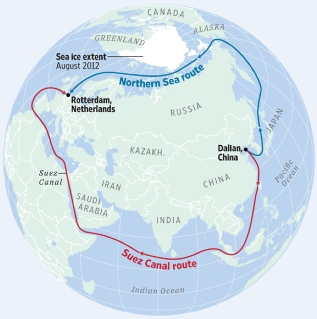
An illustration by the European University at St. Petersburg shows the Northern Sea shipping route, which a Russian tanker traversed for the first time ever in the winter in February 2021, and the southern Suez Canal route.EUROPEAN UNIVERSITY AT ST. PETERSBURG
Last year, Russia moved almost 33 million tons of cargo along the Northern Sea Route, including over 18 million tons of LNG. Cargo traffic along the NSR has grown almost fivefold in the past five years alone.
“The route can handle a lot more than that,” Russian Deputy Prime Minister Yury Trutnev said during a government meeting last week. He said that according to a decree issued by President Vladimir Putin, cargo traffic along the NSR should rise to 80 million tons per year by 2024.
“One way that target can be achieved is by expanding the period of Arctic navigation,” Trutnev said.
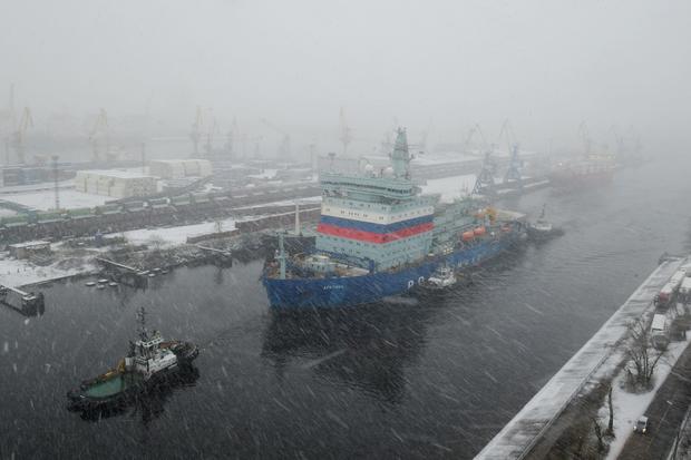
To help it achieve its lucrative Arctic ambitions, Russia has been renewing its unique civilian fleet of nuclear-powered icebreakers. Last year Russia unveiled the new flagship of that fleet, the Arktika, said to be the world’s biggest and most powerful.
Nuclear-powered icebreaker Arktika returns to Saint Petersburg on December 14, 2019, after tests.OLGA MALTSEVA/AFP/GETTY
“Russia’s Arctic attracts many who are interested in its resources,” St. Petersburg Governor Georgy Poltavchenko said at the launch ceremony. “But the Arctic is ours, and we’ve proved it.”
By the end of 2022 Russia plans to launch two more ships in the same series.
According to some estimates, the Arctic holds oil and gas reserves equivalent to 412 billion barrels of oil, about 22% of the world’s undiscovered oil and gas.


 Scroll back up to restore default view.
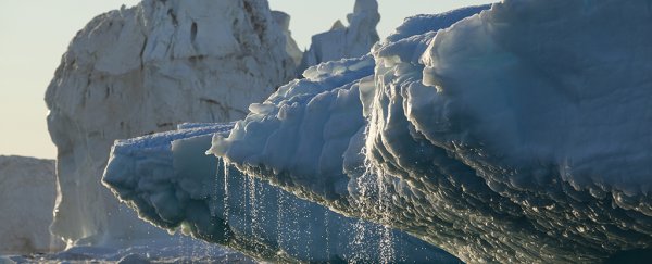


 streaking south across the Barents Sea indicate convection rolls of warm, moist air rising from the ice-free surface. Credit: NASA")

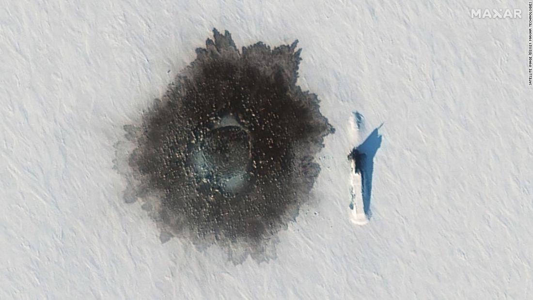 A Russian Delta IV submarine photographed on top of ice near Alexandra Island on March 27, during an exercise, with a likely hole blown in the ice to its left from underwater demolition.Yet a series of developments in the Arctic — including, according to Russian media reports, the testing of up to three Russian submarines designed to carry the stealth weapon, which has been suggested to be 20 meters long — have now led analysts to consider the project real and active.Russia’s state news agency, RIA Novosti, cited a “source” on Monday saying that tests for the Belgorod submarine, especially developed to be armed with the Poseidon torpedo, would be completed in September.Manash Pratim Boruah, a submarine expert at Jane’s Fighting Ships, said: “The reality of the weapon is clear. You can absolutely see development around the torpedo, which is happening. There is a very good probability that the Poseidon will be tested, and then there is a danger of it polluting a lot. Even without a warhead, but definitely with just a nuclear reactor inside.”Boruah said some of the specifications for the torpedo leaked by the Russians were optimistic and doubted it could reach a speed of 100 knots (around 115 miles per hour) with a 100MW nuclear reactor. He added that at such a speed, it would probably be detected quite easily as it would create a large acoustic signature.”Even if you tone it down from the speculation, it is still quite dangerous,” he said.Source: Satellite image ©2021 Maxar Technologies, Center for Strategic and International Studies (CSIS). Graphic: Henrik Pettersson, CNNBoruah added that the construction of storage bays for the Poseidon, probably around Olenya Guba on the Kola Peninsula, were meant to be complete next year. He also expressed concerns about the Tsirkon hyper-sonic missile that Russia says it has tested twice already, which at speeds of 6 to 7 Mach would “definitely cause a lot of damage without a particularly having big warhead itself.”Katarzyna Zysk, professor of international relations at the state-run Norwegian Institute for Defence Studies, said the Poseidon was “getting quite real,” given the level of infrastructure development and testing of submarines to carry the torpedo.”It is absolutely a project that will be used to scare, as a negotiation card in the future, perhaps in arms control talks,” Zysk said. “But in order to do so, it has to be credible. This seems to be real.”Stensønes also raised the concern that testing such nuclear weapons could have serious environmental consequences. “We are ecologically worried. This is not only a theoretical thing: in fact, we have seen serious accidents in the last few years,” he said, referring to the testing of the Burevestnik missile which was reported to have caused a fatal nuclear accident in 2019. “The potential of a nuclear contamination is absolutely there.”
 The Yamal Peninsula in the Russian Arctic in summer 2020. Seventeen of these holes have been discovered since 2014. (Kyodo photo/courtesy of Russian researchers)
